IMAGES TAKEN NEAR TO
Penketh Avenue, MANCHESTER, M29 7DS
Introduction
This page details the photographs taken nearby to Penketh Avenue, M29 7DS by members of the Geograph project.
The Geograph project started in 2005 with the aim of publishing, organising and preserving representative images for every square kilometre of Great Britain, Ireland and the Isle of Man.

There are currently over 7.5m images from over14,400 individuals and you can help contribute to the project by visiting https://www.geograph.org.uk
Image Map
Images are licensed for reuse under creativecommons.org/licenses/by-sa/2.0
Notes
- Clicking on the map will re-center to the selected point.
- The higher the marker number, the further away the image location is from the centre of the postcode.
Image Listing (18 Images Found)
Images are licensed for reuse under creativecommons.org/licenses/by-sa/2.0
Image
Details
Distance
1
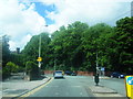
Manchester Road at Hen Fold Road junction
Image: © Colin Pyle
Taken: 6 Jun 2012
0.06 miles
2
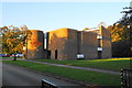
Church of St Stephen, Astley
Rebuilt on a new site further west than the original. It is part of a united benefice with Tyldesley and Mosley Common.
Image: © Bill Boaden
Taken: 18 Oct 2018
0.08 miles
3
The Bull's Head, Astley 1974
A very different looking pub from the current one - compare withImage
Image: © Chris Denny
Taken: Unknown
0.10 miles

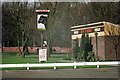
5
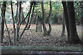
The site of the old Church of St Stephen
The Anglican church which used to be on this site was destroyed by fire in 1961. A replacement has been built a little further west.
Image: © Bill Boaden
Taken: 18 Oct 2018
0.11 miles
6
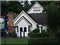
Bulls Head, Astley
Pub on Manchester Road. Serves 2 cask ales and does meals all day.
Image: © Adie Jackson
Taken: 7 Sep 2007
0.15 miles
8
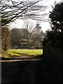
Looking back
Beyond the green field is the East Lancs Road, behind the trees. Astley Green colliery headgear is in the distance,
Image: © SMJ
Taken: 26 Dec 2008
0.16 miles
9

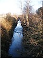
Dam House
The pond in the grounds of Dam House. Once home to the Mort Family this historic house is open to the Community and is owned by a heritage trust.
Image: © SMJ
Taken: 29 Jul 2008
0.17 miles