IMAGES TAKEN NEAR TO
Old Clough Lane, MANCHESTER, M28 7JB
Introduction
This page details the photographs taken nearby to Old Clough Lane, M28 7JB by members of the Geograph project.
The Geograph project started in 2005 with the aim of publishing, organising and preserving representative images for every square kilometre of Great Britain, Ireland and the Isle of Man.

There are currently over 7.5m images from over14,400 individuals and you can help contribute to the project by visiting https://www.geograph.org.uk
Image Map
Images are licensed for reuse under creativecommons.org/licenses/by-sa/2.0
Notes
- Clicking on the map will re-center to the selected point.
- The higher the marker number, the further away the image location is from the centre of the postcode.
Image Listing (12 Images Found)
Images are licensed for reuse under creativecommons.org/licenses/by-sa/2.0
Image
Details
Distance
1
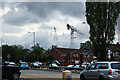
Houses hiding the work on the new Walkden High School
Image: © Ian Greig
Taken: 7 Jul 2010
0.04 miles
2
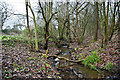
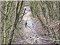
A stream which runs towards the Scout hut and probably feeds Old Warke Dam
Image: © Ian Greig
Taken: 23 Jan 2015
0.05 miles
3
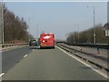
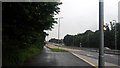
A580 crosses the LNW line to Bolton
The brick parapets mark the one-time course of the railway line from Manchester (Exchange) to Bolton (Great Moor Street). Something rather unfortunate appears to have befallen the Armco in the central reservation.
Image: © Peter Whatley
Taken: 24 Mar 2011
0.07 miles
4
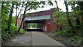
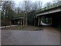
East Lancashire Road Bridge
Across the cyclepath on the route of the former railway known as the Roe Green Loopline
Image: © Kevin Waterhouse
Taken: 6 Jun 2023
0.10 miles
5
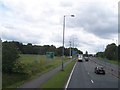
A580 - Old Clough Lane junction
A staggered crossroads on the busy East Lancashire Road.
Image: © Peter Whatley
Taken: 24 Mar 2011
0.12 miles
6
Telecommunication mast alongside the East Lancs Road
Image: © Raymond Knapman
Taken: 24 Jun 2011
0.13 miles
7
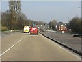
A580 near Old Clough Lane junction
The traffic lights on the left hand side are newly installed, as part of the bus priority works on the A580 East Lancashire Road. Read more about the works at http://www.tfgm.com/buspriority/routes/Pages/A580.aspx.
Image: © Bradley Michael
Taken: 1 Jul 2016
0.16 miles
8
The Loopline
The Tyldesley Loopline was the Manchester and Wigan Railway line from Eccles to the junction west of Tyldesley station and its continuance south west via Bedford Leigh to Kenyon Junction. The line opened on September 1st 1864 with a branch line leaving the Tyldesley to Eccles line at Roe Green with stations at Walkden, Little Hulton and Plodder Lane was opening in 1870.
The line closed in 1969. The former trackbed which passes through the Wigan MBC area was reserved in the Unitary Development Plan in case the rail route could be reinstated. Salford City Council has used the trackbed of the railway for recreational purposes turning it into a rail trail, part of which can be seen here at Roe Green.
Image: © David Dixon
Taken: 24 Feb 2011
0.22 miles
9
Path junction at Roe Green
The left fork is the Tyldesley Loopline, and the right fork is the Roe Green Loopline. The image was taken from next to the bench in Image
Image: © Bradley Michael
Taken: 31 Dec 2022
0.24 miles
10
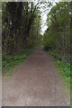
Disused Railway Line - Worsley
Now a national cycle path
Image: © Anthony Parkes
Taken: 13 May 2010
0.25 miles