IMAGES TAKEN NEAR TO
M28 5EH
Introduction
This page details the photographs taken nearby to M28 5EH by members of the Geograph project.
The Geograph project started in 2005 with the aim of publishing, organising and preserving representative images for every square kilometre of Great Britain, Ireland and the Isle of Man.

There are currently over 7.5m images from over14,400 individuals and you can help contribute to the project by visiting https://www.geograph.org.uk
Image Map
Images are licensed for reuse under creativecommons.org/licenses/by-sa/2.0
Notes
- Clicking on the map will re-center to the selected point.
- The higher the marker number, the further away the image location is from the centre of the postcode.
Image Listing (39 Images Found)
Images are licensed for reuse under creativecommons.org/licenses/by-sa/2.0
Image
Details
Distance
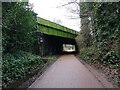
1
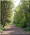
Disused Railway
The last colliery in the area to close was Mosley Common in 1968 and remarkably little evidence remains in Walkden of this once mighty industry. The routes of some colliery railways, such as this one to the east of Walkden Road, have been transformed into walking and cycle routes and are part of the Salford Loop Line network of cycleways.
Image: © David Dixon
Taken: 23 May 2010
0.06 miles
2
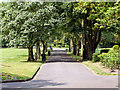
Roe Green loopline, Walkden
The view in the direction of Roe Green from just east of Walkden Road.
Image: © Bradley Michael
Taken: 24 Dec 2022
0.07 miles
3
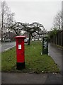
Parr Fold, postbox
At the corner of Walkden Road and Edge Fold Road, GVIR postbox, ID M28 50.
Image: © Mike Faherty
Taken: 13 Jan 2011
0.11 miles
5
Walkden Road bridge
The imposing and garish bridge as seen from the Roe Green loopline. Beyond the bridge is Parr Fold park and Little Hulton.
Image: © Bradley Michael
Taken: 24 Dec 2022
0.13 miles
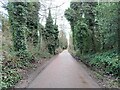
6
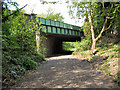
Disused Railway, Walkden Road Bridge
The last colliery in the area to close was Mosley Common in 1968 and remarkably little evidence remains in Walkden of this once mighty industry. The routes of some colliery railways, such as this one passing under Walkden Road, have been transformed into walking and cycle routes and are part of the Salford Loop Line network of cycleways.
Image: © David Dixon
Taken: 23 May 2010
0.13 miles
7
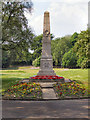
Walkden War Memorial
The War memorial in Parr Fold Park.
Image: © David Dixon
Taken: 23 May 2010
0.14 miles
8
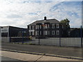
Walkden High School - Specialist Language College
Image: © Anthony Parkes
Taken: 20 Jun 2010
0.14 miles
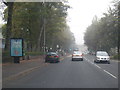
10
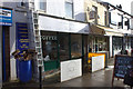
Walkden Road businesses
A general hardware store and two cafes.
Image: © Robert Eva
Taken: 17 Nov 2017
0.16 miles