IMAGES TAKEN NEAR TO
The Delph, Worsley Road, MANCHESTER, M28 2GD
Introduction
This page details the photographs taken nearby to The Delph, Worsley Road, M28 2GD by members of the Geograph project.
The Geograph project started in 2005 with the aim of publishing, organising and preserving representative images for every square kilometre of Great Britain, Ireland and the Isle of Man.

There are currently over 7.5m images from over14,400 individuals and you can help contribute to the project by visiting https://www.geograph.org.uk
Image Map
Images are licensed for reuse under creativecommons.org/licenses/by-sa/2.0
Notes
- Clicking on the map will re-center to the selected point.
- The higher the marker number, the further away the image location is from the centre of the postcode.
Image Listing (182 Images Found)
Images are licensed for reuse under creativecommons.org/licenses/by-sa/2.0
Image
Details
Distance
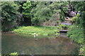
1
Worsley Delph
Worsley Delph was the entrance to the Duke of Bridgewater's underground mines from the Bridgewater Canal. It gave access to 74 km of underground canal on four levels.
Image: © habiloid
Taken: 25 Mar 2016
0.02 miles
2
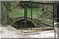
Worsley Delph - left hand entrance
One of the two canal entrances into the coal mines is behind the crane-like structure, actually a sluice for assisting boats out of the tunnel. The red water comes from iron strata in the mines. It was possible at one time to navigate continuously into the mine for 10,900 yards (9960 m) before reaching a dead-end, easily eclipsing double-ended tunnels on ordinary British canals. There were many branches and also four other navigable levels, totalling over 51 miles (82 km), although not all open at once. The two entrances here formed a "dual carriageway" to ease the heavy boat traffic.
Image: © Robin Webster
Taken: 18 Sep 1990
0.02 miles
3
Mine entrance, Worsley Delph
The 'right hand' entrance to the Duke of Bridgewater's mine. The waterway continued inside the mine and barges would carry the coal out.
Image: © Chris Denny
Taken: Unknown
0.02 miles
4
The path to Worsley Delph
Pathway leading down to the right hand entrance of the Duke of Bridgewater's mine. Taken in 1974 when there was public access (or I was trespassing).
Image: © Chris Denny
Taken: Unknown
0.02 miles
5
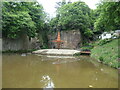
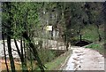
Worsley Delph
A replica crane, outlines of the boats that moved coal around the mine, and the low entrance to the mine [behind the bridge]. The sandstone quarry was repurposed as a canal basin in 1761. This site has excellent interpretation, installed by Salford City Council in 2019 with National Lottery money.
Image: © Christine Johnstone
Taken: 29 May 2021
0.03 miles
6

The left hand mine entrance, Worsley Delph
Seen from behind the sluice winding wheel.
Image: © Chris Denny
Taken: Unknown
0.03 miles
7
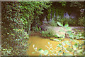
The Delph
Basin on The Bridgwater Canal formed by the quarrying of sandstone for the canal, its bridges and Eccles parish church http://www.geograph.org.uk/photo/2115601 Either side of the small promontory are Brindley's entrances to the 52-mile labyrinth of underground tunnels
Image: © Richard Croft
Taken: 24 Feb 2011
0.03 miles
9
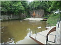
Viewing platform, Worsley Delph
The Delph is a sandstone quarry which was repurposed as a loading basin in 1761 when coal was mined here and the Bridgewater Canal opened. The rusty red structure is a modern replica of the original crane and in the water are outlines of the kind of boats that worked in the coal mines on underground canals. This site has excellent interpretation, installed by Salford City Council in 2019 with National Lottery money.
Image: © Christine Johnstone
Taken: 29 May 2021
0.04 miles
10
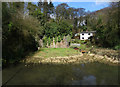
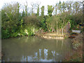
Worsley Delph with nesting swans
An iconic industrial archaeology site, now pleasantly sylvan. Sadly there is no longer public access.
Image: © Chris Allen
Taken: 7 Jun 2009
0.04 miles