IMAGES TAKEN NEAR TO
Banksman Way, MANCHESTER, M27 8WD
Introduction
This page details the photographs taken nearby to Banksman Way, M27 8WD by members of the Geograph project.
The Geograph project started in 2005 with the aim of publishing, organising and preserving representative images for every square kilometre of Great Britain, Ireland and the Isle of Man.

There are currently over 7.5m images from over14,400 individuals and you can help contribute to the project by visiting https://www.geograph.org.uk
Image Map
Images are licensed for reuse under creativecommons.org/licenses/by-sa/2.0
Notes
- Clicking on the map will re-center to the selected point.
- The higher the marker number, the further away the image location is from the centre of the postcode.
Image Listing (20 Images Found)
Images are licensed for reuse under creativecommons.org/licenses/by-sa/2.0
Image
Details
Distance
1
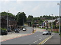
Agecroft Road
Looking SW along Agecroft Road, Pendlebury. SD79720156
Image: © Keith Williamson
Taken: 5 Sep 2005
0.09 miles
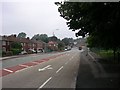
2
Railway Bridge, Agecroft Road
Agecroft Road, Pendlebury.
Image: © David Dixon
Taken: 28 Mar 2010
0.10 miles
4
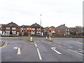
Traffic Light Junction - Agecroft Road
Image: © Anthony Parkes
Taken: 4 Apr 2011
0.12 miles
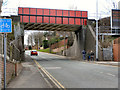
5
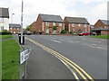
Manchester's Old Ring Road
Before Manchester wisely invested in motorways, this was the principal route around Manchester's northern suburbs. In that era, it was only as wide as the section visible under the bridge, at which point a short, severe slope rises to the main Bolton road. Hugely unfunny with nose to tail traffic of all sizes and shapes, all with rather less powerful brakes and engines than today.
Image: © Peter Whatley
Taken: 1 Jul 2009
0.12 miles
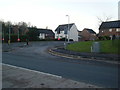
6
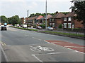
What Happened To Agecroft?
Few traces remain of industrial Agecroft, dominated by its colliery, power station and ancillary works - all notable landmarks adjacent to the old Manchester ring road. This modern housing estate occupies what used to be the Thermalite works: a factory producing construction blocks out of waste ash from the power station. The rest has been landscaped out of all recognition.
Image: © Peter Whatley
Taken: 1 Jul 2009
0.13 miles
8
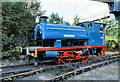
RSH Saddle Tank Locomotive at Agecroft Power Station
Image: © David Dixon
Taken: 12 Sep 1981
0.20 miles
9
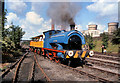
Steam Railway at Agecroft Power Station
Saddle tank locomotive "Agecroft No 2", complete with replica 1830s carriages, gives passenger rides during the open day to mark the last day of operation for the three steam locomotives at Agecroft Power Station. The power station's two huge stacks and cooling towers, which can be seen behind the locomotives, were demolished in 1994 (https://www.flickr.com/photos/ianfitter/sets/72157623104950245/ flickr). The site now has a mixed development of housing, parklands and a prison, HMP Forest Bank which was opened in January 2000. The locomotive has been preserved and is now operating on the Ribble Steam Railway https://ribblesteam.org.uk/2-uncategorised/45-rsh-7485-1947-agecroft-no-2 .
Image: © David Dixon
Taken: 12 Sep 1981
0.20 miles
10
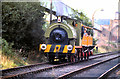
Railway Sidings at Agecroft Power Station
RSH saddle tank locomotive "Agecroft 3", complete with replica 1830s carriages, gives passenger rides during the open day to mark the last day of operation for the three steam locomotives at Agecroft Power Station. Built in 1948 and purchased by the Salford Corporation Electricity Department to shunt coal wagons between the Agecroft Colliery the power station on the opposite side of Agecroft Road. The railway became largely obsolete when the conveyor (above and to the left of the train) was built to carry coal from the mines.
Image: © David Dixon
Taken: 12 Sep 1981
0.20 miles