IMAGES TAKEN NEAR TO
Blue Ribbon Walk, MANCHESTER, M27 4RW
Introduction
This page details the photographs taken nearby to Blue Ribbon Walk, M27 4RW by members of the Geograph project.
The Geograph project started in 2005 with the aim of publishing, organising and preserving representative images for every square kilometre of Great Britain, Ireland and the Isle of Man.

There are currently over 7.5m images from over14,400 individuals and you can help contribute to the project by visiting https://www.geograph.org.uk
Image Map
Images are licensed for reuse under creativecommons.org/licenses/by-sa/2.0
Notes
- Clicking on the map will re-center to the selected point.
- The higher the marker number, the further away the image location is from the centre of the postcode.
Image Listing (24 Images Found)
Images are licensed for reuse under creativecommons.org/licenses/by-sa/2.0
Image
Details
Distance
1
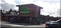
ASDA Pendlebury Supermarket
There is a larger ASDA in Swinton shopping centre, about a 10 minute walk from this store.
Image: © Bradley Michael
Taken: 24 Sep 2015
0.10 miles
2
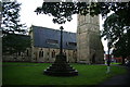
Memorial cross outside Christ Church
Christ Church is now occupied by the Assemblies of God, one of the Pentecostal churches. The cross has no obvious plaques saying what it is for.
Image: © Bill Boaden
Taken: 18 Sep 2012
0.10 miles
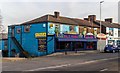
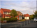
4
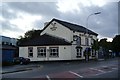
The Royal Oak, Swinton
One of the few surviving pubs on this stretch of Bolton Road.
Image: © Bill Boaden
Taken: 18 Sep 2012
0.11 miles
5
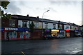
Row of shops on Bolton Road, Swinton
These are opposite a Tesco Express which probably absorbs most of the local convenience store market.
Image: © Bill Boaden
Taken: 18 Sep 2012
0.13 miles
6
Bilash
The Bilash Balti House on Bolton Road in Pendlebury.
Image: © Peter McDermott
Taken: 7 Feb 2015
0.15 miles
7
Former Public House
The Royal Oak, on Bolton Road appears to be apartments
Image: © Kevin Waterhouse
Taken: 12 Jul 2023
0.16 miles
8
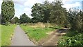
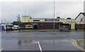
Path junction, LIVIA, Silverdale
Surprisingly there are very few images of this area as of time of uploading! It's quite a big area of woodland. LIVIA stands for Lower Irwell Valley Improvement Area.
Image: © Bradley Michael
Taken: 24 Sep 2015
0.20 miles
9
Lions used to play here!
Swinton Rugby League Football Club (the Lions) used to have a stadium here before falling on hard times. Now a housing development. SD7780209
Image: © Keith Williamson
Taken: 30 Aug 2005
0.21 miles
10
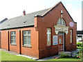
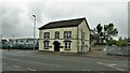
Salvation Army, Station Road
Pendlebury Salvation Army hall is located in Station Road, Swinton
Image: © Rob K Brettle
Taken: Unknown
0.21 miles