IMAGES TAKEN NEAR TO
Martingale Close, MANCHESTER, M26 4YA
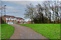
Introduction
This page details the photographs taken nearby to Martingale Close, M26 4YA by members of the Geograph project.
The Geograph project started in 2005 with the aim of publishing, organising and preserving representative images for every square kilometre of Great Britain, Ireland and the Isle of Man.

There are currently over 7.5m images from over14,400 individuals and you can help contribute to the project by visiting https://www.geograph.org.uk
Image Map
Images are licensed for reuse under creativecommons.org/licenses/by-sa/2.0
Notes
- Clicking on the map will re-center to the selected point.
- The higher the marker number, the further away the image location is from the centre of the postcode.
Image Listing (161 Images Found)
Images are licensed for reuse under creativecommons.org/licenses/by-sa/2.0
Image
Details
Distance
1
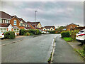
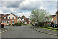
Radcliffe, Shetland Way
Part of a housing estate built in the 1990s.
Image: © David Dixon
Taken: 2 Oct 2021
0.07 miles
2
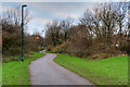
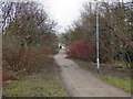
Footpath behind Shetland Way
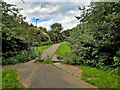
This "green corridor" separates the 1970s estate (on the left) from the 1990s estate (on the right). It was created when the latter estate was built on land which had previously been farmland.
Image: © David Dixon
Taken: 11 Jan 2019
0.08 miles
3
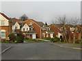
Chestnut Fold
Part of a housing estate constructed in the early 1990s.
Image: © David Dixon
Taken: 2 May 2021
0.08 miles
4
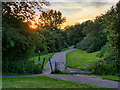
Footpath behind the Recycling Centre
Green corridor between the recycling centre and the new (1990s) houses on Shetland Way.
Image: © David Dixon
Taken: 25 Jun 2020
0.08 miles
5
Chestnut Fold
Part of a housing development built during the early 1990s
Image: © David Dixon
Taken: 23 Mar 2012
0.08 miles
6
Bridle Fold
The edge of a housing estate built in the early 1990s.
Image: © David Dixon
Taken: 11 Jan 2019
0.09 miles
7
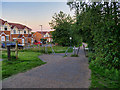
Footpath Behind Shetland Way
Footpath running from Cemetery Road/Greenbank Road to Belgrave Street/Chestnut Fold. Behind the bushes to the left of the photograph are the houses of Shetland Way; behind those on the right, is the "Cemetery Road Household Waste Recycling Centre" (aka "Radcliffe Tip").
Image: © David Dixon
Taken: 1 Jan 2011
0.09 miles