IMAGES TAKEN NEAR TO
Turks Road, MANCHESTER, M26 4QB
Introduction
This page details the photographs taken nearby to Turks Road, M26 4QB by members of the Geograph project.
The Geograph project started in 2005 with the aim of publishing, organising and preserving representative images for every square kilometre of Great Britain, Ireland and the Isle of Man.

There are currently over 7.5m images from over14,400 individuals and you can help contribute to the project by visiting https://www.geograph.org.uk
Image Map
Images are licensed for reuse under creativecommons.org/licenses/by-sa/2.0
Notes
- Clicking on the map will re-center to the selected point.
- The higher the marker number, the further away the image location is from the centre of the postcode.
Image Listing (55 Images Found)
Images are licensed for reuse under creativecommons.org/licenses/by-sa/2.0
Image
Details
Distance
1
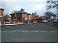
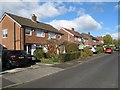
Turks Road
A view of respectable semi-detached housing along Turks Road, looking in the direction of Bolton.
Image: © Jonathan Wilkins
Taken: 23 Oct 2016
0.01 miles
2
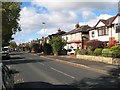
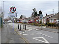
Turks Road, Radcliffe
The cream building on the left is a newsagents.
Image: © Bradley Michael
Taken: 15 Sep 2015
0.06 miles
3
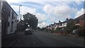
Pilkington Road
Looking northwards along this fine terrace of houses to the junction with Turks Road.
Image: © Jonathan Wilkins
Taken: 23 Oct 2016
0.08 miles
4
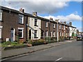
Semi-detached houses, Northlands
Well-established and sought-after houses to the north of Radcliffe.
Image: © Jonathan Wilkins
Taken: 23 Oct 2016
0.08 miles
5
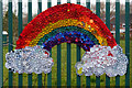
Chase the Rainbow
During the 2020 coronavirus pandemic https://en.wikipedia.org/wiki/2020_coronavirus_pandemic_in_the_United_Kingdom the UK government imposed restrictions on travel and people were no longer allowed to congregate in groups. All restaurants, pubs, clubs and indoor sport and leisure facilities were ordered to close. People were asked to work from home where possible and schools were closed to all except vulnerable pupils and children of ‘key workers’ who had to carry on working.
During this time, a number of rainbows started to appear. Usually painted by children and placed in windows but also, sometimes chalked on pavements or other more elaborate decorations on the outside of houses https://www.hellomagazine.com/homes/gallery/2020033187217/coronavirus-rainbow-displays-windows-photos/9/ This trend appears to have started in Italy but has also been adopted in the US, Canada and Spain, where people have adorned their windows and balconies with colourful pictures.
Rainbows are used as a symbol of peace and hope as they often appear when the sun follows a heavy rainfall. They serve to remind us that there is hope and light to follow even after dark times. Children and parents have been encouraged to share photos of their rainbows on social media using the tags #RainbowTrail and #ChaseTheRainbow.
This example, created from old bottle-tops is attached to the railings of the Wesleyan Methodist Primary School.
Image: © David Dixon
Taken: 28 Mar 2020
0.13 miles
7
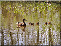
Redbank Lodges (7)
The smallest of the three lodges.
Image: © David Dixon
Taken: 14 Apr 2020
0.16 miles
9
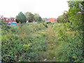
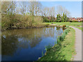
Disused Railway, Black Lane
The course of the former Liverpool and Bury (later Lancashire and Yorkshire) Railway, at Black Lane.
The Liverpool and Bury Railway was formed in 1845. In 1847, it was incorporated into the Lancashire and Yorkshire Railway and from 1922, until nationalisation, was part of the London, Midland and Scottish Railway.
The line between Bolton and Bury was closed in 1970 and part of the route, as here, is now a footpath although it has been built over in other places (http://menmedia.co.uk/heywoodadvertiser/news/s/390183_rail_decision_spells_gloom_for_lines_future - Heywood Advertiser).
http://www.lyrs.org.uk/the_railway/ - The Lancashire and Yorkshire Railway Society
http://en.wikipedia.org/wiki/Lancashire_and_Yorkshire_Railway - L&YR article on Wikipedia
Image: © David Dixon
Taken: 30 Jun 2011
0.16 miles