IMAGES TAKEN NEAR TO
Bury & Bolton Road, MANCHESTER, M26 4JY
Introduction
This page details the photographs taken nearby to Bury & Bolton Road, M26 4JY by members of the Geograph project.
The Geograph project started in 2005 with the aim of publishing, organising and preserving representative images for every square kilometre of Great Britain, Ireland and the Isle of Man.

There are currently over 7.5m images from over14,400 individuals and you can help contribute to the project by visiting https://www.geograph.org.uk
Image Map
Images are licensed for reuse under creativecommons.org/licenses/by-sa/2.0
Notes
- Clicking on the map will re-center to the selected point.
- The higher the marker number, the further away the image location is from the centre of the postcode.
Image Listing (29 Images Found)
Images are licensed for reuse under creativecommons.org/licenses/by-sa/2.0
Image
Details
Distance
3
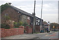
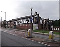
Cottages on Bury and Bolton Road
According to a 1908 OS map, these cottages then stood alone and were named Wilton Hill. Across the road was a milestone that read Bolton 4 miles and Bury 1 and 3/4 miles. Alas, the stone is no longer there.
Image: © philandju
Taken: 31 Jan 2012
0.03 miles
4
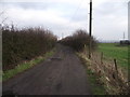
Track leading to Higher Spen Moor
Off Bury and Bolton Road (A58), Higher Spen Moor is a farm. The track becomes a footpath at the farm, leading eventually to Elton Reservoir.
Image: © philandju
Taken: 31 Jan 2012
0.07 miles
5
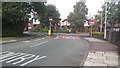
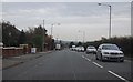
One way junction on Grindsbrook Road
Unless you are on a cycle! Not sure about the reason for prohibited access, possibly something to do with the 40 mph speed limit and the near by traffic light junction.
Image: © Bradley Michael
Taken: 15 Sep 2015
0.09 miles
6
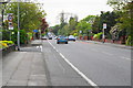
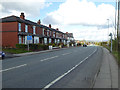
Bury and Bolton Road
The A58 west of Bury. At this point there is a powerful smell of curry, emanating from the Mumbai Lounge a little further along the road.
Image: © Bill Boaden
Taken: 19 May 2012
0.10 miles
7
The Dil Se Indian Restaurant , Bury & Bolton Rd. Radcliffe
This restaurant used to be a pub called The Jolly Carters in my salad days .
Image: © Janet Huige
Taken: 29 Sep 2006
0.10 miles
8
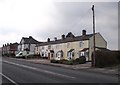
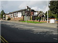
The Mumbai Lounge
On Bury and Bolton Road, this building was once a pub and is now an Indian restaurant.
Image: © philandju
Taken: 31 Jan 2012
0.12 miles
9
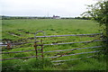
Field near Higher Spen Moor Farm
Looking towards northern Radcliffe, where Constellation Mill stands out. The spire of St Andrew's Church is just to the left of it.
Image: © Bill Boaden
Taken: 19 May 2012
0.12 miles