IMAGES TAKEN NEAR TO
Crosby Road, MANCHESTER, M26 4JL
Introduction
This page details the photographs taken nearby to Crosby Road, M26 4JL by members of the Geograph project.
The Geograph project started in 2005 with the aim of publishing, organising and preserving representative images for every square kilometre of Great Britain, Ireland and the Isle of Man.

There are currently over 7.5m images from over14,400 individuals and you can help contribute to the project by visiting https://www.geograph.org.uk
Image Map
Images are licensed for reuse under creativecommons.org/licenses/by-sa/2.0
Notes
- Clicking on the map will re-center to the selected point.
- The higher the marker number, the further away the image location is from the centre of the postcode.
Image Listing (30 Images Found)
Images are licensed for reuse under creativecommons.org/licenses/by-sa/2.0
Image
Details
Distance
1
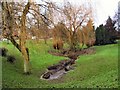
Weeping Willows at Ainsworth
This brook meanders from north to south, disappearing underground again at this point, to re-appear lower down the B6292 towards Radcliffe.
Image: © Roger May
Taken: 21 Dec 2005
0.04 miles
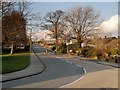
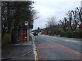
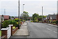
3
Radcliffe, Higher Ainsworth Road
Looking down the hill, along Higher Ainsworth Road, from Three Arrows towards Radcliffe.
Image: © David Dixon
Taken: 9 Jul 2014
0.09 miles
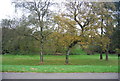
4
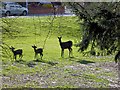
Grindsbrook Deer
At first glance, this appeared to be a family of deer running through the trees between Grindsbrook Road and Higher Ainsworth Road. Disappointingly, however, closer inspection showed them to be wooden cut-out figures.
Image: © David Dixon
Taken: 30 Apr 2016
0.09 miles
7
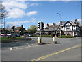
Ainsworth Arms Junction
This is the junction of the A58 Bury New Road and the B6292 Higher Ainsworth Road.
The Ainsworth Arms public house is on the corner.
Image: © Paul Anderson
Taken: 11 Apr 2007
0.13 miles
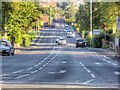
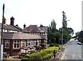
8
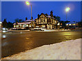
Three Arrows
The crossroads of the A58 (Bury and Bolton Road) and B6292 (Starling Road/Ainsworth Road) has traditionally been known as "Three Arrows". The large pub/restaurant opposite, now called "The Ainsworth Arms" was formerly called "The Three Arrows".
Image: © David Dixon
Taken: 26 Jan 2013
0.13 miles
9
Grindsbrook Road
This could be a rat run, cutting off a corner between the A58 and the B6292 to Radcliffe, but it is only of benefit in a southerly direction.
Image: © Bill Boaden
Taken: 19 May 2012
0.13 miles