IMAGES TAKEN NEAR TO
Pendennis Close, MANCHESTER, M26 3UH
Introduction
This page details the photographs taken nearby to Pendennis Close, M26 3UH by members of the Geograph project.
The Geograph project started in 2005 with the aim of publishing, organising and preserving representative images for every square kilometre of Great Britain, Ireland and the Isle of Man.

There are currently over 7.5m images from over14,400 individuals and you can help contribute to the project by visiting https://www.geograph.org.uk
Image Map
Images are licensed for reuse under creativecommons.org/licenses/by-sa/2.0
Notes
- Clicking on the map will re-center to the selected point.
- The higher the marker number, the further away the image location is from the centre of the postcode.
Image Listing (35 Images Found)
Images are licensed for reuse under creativecommons.org/licenses/by-sa/2.0
Image
Details
Distance
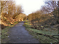
1
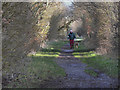
Former Lancashire and Yorkshire Railway Route
Looking along the route of the former Liverpool and Bury (later Lancashire and Yorkshire) Railway. This view is looking in the direction of Radcliffe (Ainsworth Road and Black Lane) behind the Bradley Fold Trading Estate.
The Liverpool and Bury Railway was formed in 1845. In 1847, it was incorporated into the Lancashire and Yorkshire Railway and from 1922, until nationalisation, was part of the London, Midland and Scottish Railway.
The line between Bolton and Bury was closed in 1970 and part of the route, as here, is now a footpath although it has been built over in other places (http://menmedia.co.uk/heywoodadvertiser/news/s/390183_rail_decision_spells_gloom_for_lines_future - Heywood Advertiser).
http://www.lyrs.org.uk/the_railway/ - The Lancashire and Yorkshire Railway Society
http://en.wikipedia.org/wiki/Lancashire_and_Yorkshire_Railway - L&YR article on Wikipedia
Image: © David Dixon
Taken: 2 Jan 2012
0.05 miles
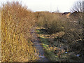
2
Route of Former Railway
Looking along the route of the former Liverpool and Bury (later Lancashire and Yorkshire) Railway. This view is looking in the direction of Radcliffe (Ainsworth Road and Black Lane) just to the east of Radcliffe Moor Road.
The Liverpool and Bury Railway was formed in 1845. In 1847, it was incorporated into the Lancashire and Yorkshire Railway and from 1922, until nationalisation, was part of the London, Midland and Scottish Railway.
The line between Bolton and Bury was closed in 1970 and part of the route, as here, is now a footpath although it has been built over in other places (http://menmedia.co.uk/heywoodadvertiser/news/s/390183_rail_decision_spells_gloom_for_lines_future - Heywood Advertiser).
http://www.lyrs.org.uk/the_railway/ - The Lancashire and Yorkshire Railway Society
http://en.wikipedia.org/wiki/Lancashire_and_Yorkshire_Railway - L&YR article on Wikipedia
Image: © David Dixon
Taken: 2 Jan 2012
0.09 miles
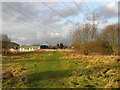
3
Radcliffe Moor
Behind the Bradley Fold Trading Estate, looking towards Coggra Fold.
Image: © David Dixon
Taken: 2 Jan 2012
0.12 miles
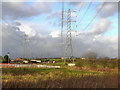
4
Behind The Trading Estate
Overhead power lines passing behind the Bradley Fold Trading Estate.
Image: © David Dixon
Taken: 2 Jan 2012
0.12 miles
5
Disused railway at Bradley Fold
Path following the route of the dismantled railway line towards Black Lane.
Image: © David Dixon
Taken: 6 Feb 2010
0.13 miles
6
Disused railway line
The disused railway line from Bolton, looking towards Black Lane as it passes the Montgomery Park estate.
Image: © David Dixon
Taken: 6 Feb 2010
0.14 miles
7
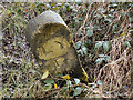
Marker Post, Lancashire and Yorkshire Railway
This stone post is near the route of the former Liverpool and Bury (later Lancashire and Yorkshire) Railway between Bradley Fold and Moss Shaw, The only markings on it are the letters LYR which presumably are for Lancashire and Yorkshire Railway. The other face of the stone is completely blank.
The Liverpool and Bury Railway was formed in 1845. In 1847, it was incorporated into the Lancashire and Yorkshire Railway and from 1922, until nationalisation, was part of the London, Midland and Scottish Railway.
The line between Bolton and Bury was closed in 1970 and part of the route, as here, is now a footpath although it has been built over in other places (http://menmedia.co.uk/heywoodadvertiser/news/s/390183_rail_decision_spells_gloom_for_lines_future - Heywood Advertiser).
http://www.lyrs.org.uk/the_railway/ - The Lancashire and Yorkshire Railway Society
http://en.wikipedia.org/wiki/Lancashire_and_Yorkshire_Railway - L&YR article on Wikipedia
Image: © David Dixon
Taken: 2 Jan 2012
0.16 miles
8
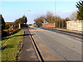
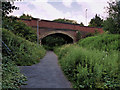
Radcliffe Moor Road
The bridge where the A665, Radcliffe Moor Road, passes over the path of the (now disused) railway.
Image: © David Dixon
Taken: 6 Feb 2010
0.16 miles
9
Bridge over the Bradley Fold Cycleway
A view of the bridge which takes the A665 (Radcliffe Moor Road) over the route of the former Liverpool and Bury (later Lancashire and Yorkshire) Railway.
The Liverpool and Bury Railway was formed in 1845. In 1847, it was incorporated into the Lancashire and Yorkshire Railway and from 1922, until nationalisation, was part of the London, Midland and Scottish Railway.
The line between Bolton and Bury was closed in 1970 and part of the route, as here, is now a footpath although it has been built over in other places (http://menmedia.co.uk/heywoodadvertiser/news/s/390183_rail_decision_spells_gloom_for_lines_future - Heywood Advertiser).
Image] shows the nearby Bradley Fold Station as it was in 1963.
http://www.lyrs.org.uk/the_railway/ - The Lancashire and Yorkshire Railway Society
http://en.wikipedia.org/wiki/Lancashire_and_Yorkshire_Railway - L&YR article on Wikipedia
Image: © David Dixon
Taken: 26 Jun 2020
0.16 miles
10
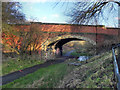
Bridge at Radcliffe Moor Road
A view of the bridge which takes the A665 (Radcliffe Moor Road) over the route of the former Liverpool and Bury (later Lancashire and Yorkshire) Railway.
The Liverpool and Bury Railway was formed in 1845. In 1847, it was incorporated into the Lancashire and Yorkshire Railway and from 1922, until nationalisation, was part of the London, Midland and Scottish Railway.
The line between Bolton and Bury was closed in 1970 and part of the route, as here, is now a footpath although it has been built over in other places (http://menmedia.co.uk/heywoodadvertiser/news/s/390183_rail_decision_spells_gloom_for_lines_future - Heywood Advertiser).
Image] shows the nearby Bradley Fold Station as it was in 1963.
http://www.lyrs.org.uk/the_railway/ - The Lancashire and Yorkshire Railway Society
http://en.wikipedia.org/wiki/Lancashire_and_Yorkshire_Railway - L&YR article on Wikipedia
Image: © David Dixon
Taken: 2 Jan 2012
0.16 miles