IMAGES TAKEN NEAR TO
St. Thomas Close, MANCHESTER, M26 3AP
Introduction
This page details the photographs taken nearby to St. Thomas Close, M26 3AP by members of the Geograph project.
The Geograph project started in 2005 with the aim of publishing, organising and preserving representative images for every square kilometre of Great Britain, Ireland and the Isle of Man.

There are currently over 7.5m images from over14,400 individuals and you can help contribute to the project by visiting https://www.geograph.org.uk
Image Map
Images are licensed for reuse under creativecommons.org/licenses/by-sa/2.0
Notes
- Clicking on the map will re-center to the selected point.
- The higher the marker number, the further away the image location is from the centre of the postcode.
Image Listing (472 Images Found)
Images are licensed for reuse under creativecommons.org/licenses/by-sa/2.0
Image
Details
Distance
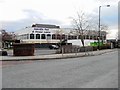
3
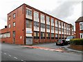
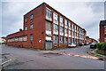
Factory on Wolsey Street
Factory at the corner of Wolsey Street and School Street.
Image: © David Dixon
Taken: 22 Feb 2014
0.03 miles
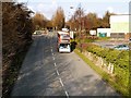
4
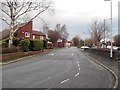
Pilkington Way (A665), Radcliffe
Pilkington Way was constructed in the 1980s as a town-centre bypass to relieve the heavy traffic congestion along the traditional route through the town, Blackburn Street. A new bridge across the Irwell was constructed for the road, and part of Blackburn Street was pedestrianised.
Image: © David Dixon
Taken: 27 Feb 2014
0.04 miles
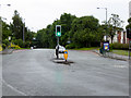
6
Radcliffe Pool
Radcliffe Pool and Fitness Centre is situated on Green Street in Radcliffe's town centre. The centre has on-site car parking and is approximately 5 minutes walk from Radcliffe bus station or 10 minutes walk from Radcliffe Metrolink station.
M26 3ED
Phone: 0161 253 7814
Image: © Pete Spooner
Taken: 30 Nov 2010
0.04 miles
7
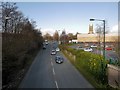
Radcliffe, Pilkington Way
Pilkington Way was constructed in the 1980s as a town-centre bypass to relieve the heavy traffic congestion along the traditional route through the town, Blackburn Street. A new bridge across the Irwell was constructed for the road, and part of Blackburn Street was pedestrianised.
Image: © David Dixon
Taken: 28 Jun 2016
0.04 miles
8
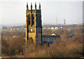
St Thomas and St John Church with St Philip, Radcliffe
St Thomas' Church is Radcliffe's most visible landmark. Here, it can be seen clearly seen from almost half a mile away in Coronation Park.
St Thomas' Church was founded in 1819. The original church was demolished and rebuilt on the same site in 1862 with the tower added 1870-71. The church, which can be seen on the horizon for many miles, is a Grade II listed building (English Heritage Building ID: 210589 http://www.britishlistedbuildings.co.uk/en-210589-church-of-st-thomas-#.VndC4nnnmHs British Listed Buildings). In 1974 the parishes of St Thomas and St John were united. http://www.st-thomas-radcliffe.org/
Image: © David Dixon
Taken: 17 Jan 2010
0.05 miles
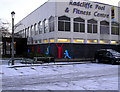
10
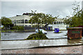
Former Radcliffe Pool and Fitness Centre
The building has been closed for some time now. There are plans to redevelop it as a civic centre.
Image: © David Dixon
Taken: 22 May 2016
0.05 miles