IMAGES TAKEN NEAR TO
Pine Street, MANCHESTER, M26 2WQ
Introduction
This page details the photographs taken nearby to Pine Street, M26 2WQ by members of the Geograph project.
The Geograph project started in 2005 with the aim of publishing, organising and preserving representative images for every square kilometre of Great Britain, Ireland and the Isle of Man.

There are currently over 7.5m images from over14,400 individuals and you can help contribute to the project by visiting https://www.geograph.org.uk
Image Map
Images are licensed for reuse under creativecommons.org/licenses/by-sa/2.0
Notes
- Clicking on the map will re-center to the selected point.
- The higher the marker number, the further away the image location is from the centre of the postcode.
Image Listing (326 Images Found)
Images are licensed for reuse under creativecommons.org/licenses/by-sa/2.0
Image
Details
Distance
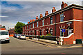
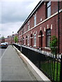
1
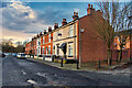
Mount Pleasant, Pine Street
A row of Victorian terraced houses; dated 1881.
Image: © David Dixon
Taken: 5 Jan 2021
0.00 miles
3
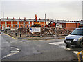
Site of former St Mary and St Philip Neri Catholic Church, Radcliffe
The church which stood at the corner of Cross Lane and Bury Road Image] was closed when the new church on Belgrave street was opened in 2009. Image]
The old church was demolished in January 2010. Behind the rubble, St Mary's social club on Pine street is still in use and can be seen to the right hand side of the picture behind the white lorry.
Image: © David Dixon
Taken: 3 Feb 2010
0.01 miles
5
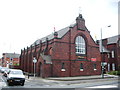
St Mary and St Philip Neri Catholic Church, Radcliffe
Image: © Alexander P Kapp
Taken: 9 May 2007
0.02 miles
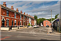
7
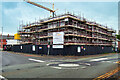
New Homes at St Mary's
New "affordable" homes being constructed on the site of the former St mary's Church on the corner of Bury Road and Spring Lane.
Image: © David Dixon
Taken: 9 Oct 2021
0.02 miles
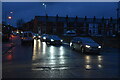
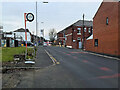
8
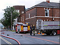
Bury Road
Bury Road, from the edge of the police cordon, still in place following the previous day's fire at the former General Engineering factory.
For more images, see http://www.geograph.org.uk/search.php?i=35454929
Read more:
http://www.independent.co.uk/news/uk/home-news/homes-evacuated-amid-factory-blaze-in-radcliffe-8078444.html (The Independent)
http://www.metro.co.uk/news/909670-radcliffe-factory-fire-causes-100-homes-to-be-evacuated#ixzz24Ul8gRvN (Metro News)
http://www.itv.com/news/granada/update/2012-08-24/radcliffe-factory-fire-explosion/ (ITV News)
http://www.towerfm.co.uk/news/local/investigation-after-massive-factory-fire-in-radcliffe/ (Tower FM)
http://www.burytimes.co.uk/news/9891409.Huge_factory_fire_in_Radcliffe/?action=complain&cid=10686350 (Bury Times)
http://menmedia.co.uk/manchestereveningnews/news/s/1587091_major-evacuation-after-gas-explosion-in-radcliffe---video-and-pictures (Manchester Evening News)
Image: © David Dixon
Taken: 24 Aug 2012
0.03 miles
9
South side of Schofield Street, Radcliffe
Image: © Alexander P Kapp
Taken: 9 May 2007
0.03 miles