IMAGES TAKEN NEAR TO
Spring Lane, MANCHESTER, M26 2TQ
Introduction
This page details the photographs taken nearby to Spring Lane, M26 2TQ by members of the Geograph project.
The Geograph project started in 2005 with the aim of publishing, organising and preserving representative images for every square kilometre of Great Britain, Ireland and the Isle of Man.

There are currently over 7.5m images from over14,400 individuals and you can help contribute to the project by visiting https://www.geograph.org.uk
Image Map
Images are licensed for reuse under creativecommons.org/licenses/by-sa/2.0
Notes
- Clicking on the map will re-center to the selected point.
- The higher the marker number, the further away the image location is from the centre of the postcode.
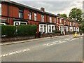
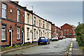
Image Listing (621 Images Found)
Images are licensed for reuse under creativecommons.org/licenses/by-sa/2.0
Image
Details
Distance
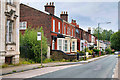
2
Laurel Bank
Terraced houses on Spring Lane. Built 1897.
Image: © David Dixon
Taken: 10 Jul 2021
0.03 miles
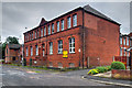
4
The Former Radcliffe Town Hall Buildings
Image: © Anthony Parkes
Taken: 22 Jul 2012
0.05 miles
5
Council Offices, Whittaker Street
The council office building on Whittaker Street, Radcliffe.
Image: © David Dixon
Taken: 3 Jan 2012
0.05 miles
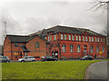
6
Bury Council Offices, Whittaker Street
This red-brick building on Whittaker Street was originally the town’s technical school which was formally opened by Lord Stanley on 7 November 1896 (https://www.british-history.ac.uk/vch/lancs/vol5/pp56-67 British History Online). It is now used as council offices.
Image: © David Dixon
Taken: 13 Jul 2020
0.05 miles
7
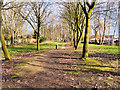
Course of Former Railway
The landscaped area to the north-west side of Darbyshire Street was previously the line of the Lancashire and Yorkshire Railway's Clifton, Accrington and Colne line which closed in 1966.
Image: © David Dixon
Taken: 18 Feb 2021
0.06 miles
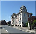
8
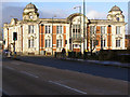
Former Town Hall
The town hall was built in 1911 on the junction of Water Street and Spring Lane. It formed the public administrative centre for the district until, under the Local Government Act 1972 the town's urban district status was abolished, and Radcliffe became, and has been since 1 April 1974,an unparished area of the Metropolitan Borough of Bury.
The building remained unoccupied for many years and now it is used as private accommodation
Image: © David Dixon
Taken: 17 Jan 2010
0.06 miles
9
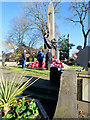
Radcliffe War Memorial
Poppy wreaths laid at Radcliffe War Memorial on Remembrance Sunday 2019.
Radcliffe Cenotaph stands in a small memorial garden, opposite the former town hall. First unveiled on 26 November 1922, it takes the form of an obelisk which rises to 35 feet above street level. The obelisk is mounted on a plinth set on a square raised terrace with surrounding walls and steps to Blackburn Street. The four main faces of the pedestal have large square bronze panels containing in relief 642 names of the fallen of 1914-1918; the narrow re-entrant sides have matching rectangular panels of names headed 1939-1945 (see Roll of Honour http://www.roll-of-honour.com/Lancashire/Radcliffe.html for a list).
The front of the obelisk has a sword with a laurel wreath around the handle; its base is surrounded by statuary on three sides. The statues, three large winged female figures are emblematic of Liberty, Victory and Peace. Victory, standing in the centre, holds Liberty by one hand and in the other holds up the laurel emblem of conquest; Liberty to the left breaks free, raising a flaming torch; Peace, to the right, reclines on one leg, with roses of remembrance in her lap, listening to the message of a dove perched on her shoulder.
The memorial is designated as a Grade II* Listed Building by English Heritage (Historic England List Entry Number: 1067192 https://historicengland.org.uk/listing/the-list/list-entry/1067192).
*In the United Kingdom, Remembrance Sunday is held on the Sunday nearest to 11 November, Armistice Day, the anniversary of the end of hostilities in the First World War at 11 am in 1918
Image: © David Dixon
Taken: 10 Nov 2019
0.06 miles
10
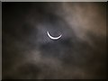
Partial Solar Eclipse, North Manchester 9.28am
After a cloudy start to the morning, with no sun visible, the clouds parted briefly at about twenty past nine, just in time to witness the moon's path crossing the sun. This photo was taken at approx 9.28am when the eclipse was at its maximum (about 90%). Compare it with Image], taken about 30 minutes later.
Both were taken through a heavy neutral density filter to reduce the amount (but not alter the colour) of the light from the sun which would otherwise have "burnt out" the photo.
Image: © David Dixon
Taken: 20 Mar 2015
0.06 miles