IMAGES TAKEN NEAR TO
Riverside Close, MANCHESTER, M26 2PJ
Introduction
This page details the photographs taken nearby to Riverside Close, M26 2PJ by members of the Geograph project.
The Geograph project started in 2005 with the aim of publishing, organising and preserving representative images for every square kilometre of Great Britain, Ireland and the Isle of Man.

There are currently over 7.5m images from over14,400 individuals and you can help contribute to the project by visiting https://www.geograph.org.uk
Image Map
Images are licensed for reuse under creativecommons.org/licenses/by-sa/2.0
Notes
- Clicking on the map will re-center to the selected point.
- The higher the marker number, the further away the image location is from the centre of the postcode.
Image Listing (95 Images Found)
Images are licensed for reuse under creativecommons.org/licenses/by-sa/2.0
Image
Details
Distance
2
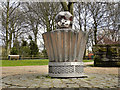
Chococupcake Boy
Chococupcake boy is one of three sculptures/public artworks at Radcliffe’s Close Park. They are all the work of artist Mark Jalland, in collaboration with pupils from Radcliffe Hall Primary School. This one is at the centre of Image See Image] for a closer view.
The three sculptures were unveiled in 2006; the others are Image] and Image
Image: © David Dixon
Taken: 7 Mar 2012
0.11 miles
3
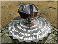
Chococupcake Boy (detail)
Chococupcake boy is one of three sculptures/public artworks at Radcliffe’s Close Park. They are all the work of artist Mark Jalland, in collaboration with pupils from Radcliffe Hall Primary School. This one is at the centre of Image
The three sculptures were unveiled in 2006; the others are Image] and Image
See Image] for context.
Image: © David Dixon
Taken: 7 Mar 2012
0.11 miles
4
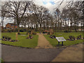
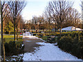
The Sensory Garden at Close Park
The sensory garden is part of Close Park which is a public park approximately 1 mile from Radcliffe town centre. The parkland was donated to the town by the Bealey family and first opened as a public park in 1925.
Image] is at the centre of the garden.
Image: © David Dixon
Taken: 7 Mar 2012
0.11 miles
5
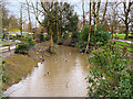
Bealey's Goit, Close Park
Bealey's Goit is/was an artificial channel constructed to supply water from the River Irwell for the Bealey's bleachworks at Radcliffe. Now redundant, it is largely overgrown except for the small section passing through Close Park. This part of the goit has been cleaned up as part of a general revamp of the park which is a public park approximately 1 mile from Radcliffe town centre. The parkland was donated to the town by the Bealey family (owners of the bleachworks) and first opened as a public park in 1925.
Image: © David Dixon
Taken: 11 Feb 2020
0.11 miles
6
Close Park
Close Park is Radcliffe's biggest public park. It is located approximately 1 mile from Radcliffe town centre. The land was first opened as a public park in 1925.
Image: © David Dixon
Taken: 31 Jan 2010
0.11 miles
7
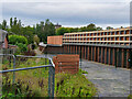
Construction of New Flood Defences at Close Park
Construction of the first phase of a major £40million flood defence scheme in Close Park is nearing completion. The scheme is designed to protect up to 873 homes in the Redvales area from a repeat of that catastrophic flooding which occurred on Boxing Day 2015 https://www.geograph.org.uk/search.php?i=110097617&displayclass=black .
The work involves the building of a 2½ metre flood wall at the rear of houses in Parkside Close, and a 3 metre-high earth embankment on the far side of the park. This embankment will integrate a footpath and landscaping 'to soften' the overall appearance. The football pitches will continue to act as a floodplain.
Image: © David Dixon
Taken: 26 Sep 2020
0.12 miles
8
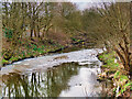
River Irwell at Redvales
Looking downstream.
Image: © David Dixon
Taken: 23 Mar 2021
0.12 miles
9
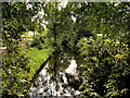
Close Park, Bealey's Goit
Bealey's Goit is/was an artificial channel constructed to supply water from the River Irwell for the Bealey's bleachworks at Radcliffe. Now redundant, it is largely overgrown except for the small section passing through Close Park. This part of the goit has been cleaned up as part of a general revamp of the park which is a public park approximately 1 mile from Radcliffe town centre. The parkland was donated to the town by the Bealey family (owners of the bleachworks) and first opened as a public park in 1925.
Image: © David Dixon
Taken: 6 Jul 2020
0.12 miles
10
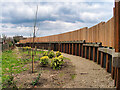
New Flood Defences at Close Park
Part of the first phase of a major £40million flood defence scheme in Close Park which is designed to protect up to 873 homes in the Redvales area from a repeat of that catastrophic flooding that occurred on Boxing Day 2015 https://www.geograph.org.uk/search.php?i=110097617&displayclass=black .
The work has involved the building a 2½ metre flood wall at the rear of houses in Parkside Close, and a 3 metre-high earth embankment on the far side of the park. This embankment integrates a footpath and landscaping 'to soften' the overall appearance. The football pitches will continue to act as a floodplain.
Compare with Image] and Image]
Image: © David Dixon
Taken: 23 Mar 2021
0.12 miles