IMAGES TAKEN NEAR TO
Stonemere Drive, MANCHESTER, M26 1QX
Introduction
This page details the photographs taken nearby to Stonemere Drive, M26 1QX by members of the Geograph project.
The Geograph project started in 2005 with the aim of publishing, organising and preserving representative images for every square kilometre of Great Britain, Ireland and the Isle of Man.

There are currently over 7.5m images from over14,400 individuals and you can help contribute to the project by visiting https://www.geograph.org.uk
Image Map
Images are licensed for reuse under creativecommons.org/licenses/by-sa/2.0
Notes
- Clicking on the map will re-center to the selected point.
- The higher the marker number, the further away the image location is from the centre of the postcode.
Image Listing (12 Images Found)
Images are licensed for reuse under creativecommons.org/licenses/by-sa/2.0
Image
Details
Distance
1
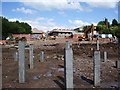
New housing on the site of Chapelfield Mill
Image: © Alexander P Kapp
Taken: 17 Jul 2007
0.02 miles
2
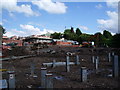
New housing on the site of Chapelfield Mill
Image: © Alexander P Kapp
Taken: 17 Jul 2007
0.02 miles
3
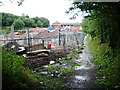
New housing on the site of Chapelfield Mill
Image: © Alexander P Kapp
Taken: 16 Jul 2007
0.03 miles
4
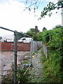
Nursery Brow (footpath)
This is the steep part of the path between Chapel Field and Outwood Gate, as it passed Chapelfield Mill, which has been demolished and is being replaced with houses. The old chimney in the background, could well have been part of Chapelfield Mill?
Image: © Alexander P Kapp
Taken: 16 Jul 2007
0.05 miles
5
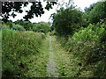
Footpath
Footpath from Chapel Field to Outwood Gate, Under all that freshly cut grass is the remains of a cobble stoned path or road, but now it can only be called a path
Image: © Alexander P Kapp
Taken: 16 Jul 2007
0.08 miles
6
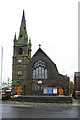
Stand United Reformed Church, Chapel Field, Radcliffe
Image: © Alexander P Kapp
Taken: 24 Oct 2005
0.15 miles
7
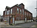
Former School
A school dated 1894 on Walker Street, Chapel Field. It now appears to be apartments.
Image: © Kevin Waterhouse
Taken: 14 May 2023
0.15 miles
8
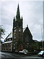
Stand United Reformed Church, Chapel Field, Radcliffe
Image: © Alexander P Kapp
Taken: 16 Jul 2007
0.16 miles
9
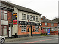
New Bay
Public house on Stand Lane at Chapelfield.
Image: © David Dixon
Taken: 8 Apr 2012
0.17 miles
10
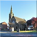
Stand United Reformed Church, Radcliffe
The large United Reformed Church on Stand Lane was built in 1885 in the Chapelfield area of Radcliffe. It is a Grade II listed building (English Heritage Building ID: 471808 http://www.britishlistedbuildings.co.uk/en-471808-stand-united-reformed-church- British Listed Buildings).
Image: © David Dixon
Taken: 5 Jul 2014
0.17 miles