IMAGES TAKEN NEAR TO
Elham Close, MANCHESTER, M26 1PL
Introduction
This page details the photographs taken nearby to Elham Close, M26 1PL by members of the Geograph project.
The Geograph project started in 2005 with the aim of publishing, organising and preserving representative images for every square kilometre of Great Britain, Ireland and the Isle of Man.

There are currently over 7.5m images from over14,400 individuals and you can help contribute to the project by visiting https://www.geograph.org.uk
Image Map
Images are licensed for reuse under creativecommons.org/licenses/by-sa/2.0
Notes
- Clicking on the map will re-center to the selected point.
- The higher the marker number, the further away the image location is from the centre of the postcode.
Image Listing (86 Images Found)
Images are licensed for reuse under creativecommons.org/licenses/by-sa/2.0
Image
Details
Distance
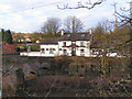
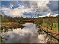
1
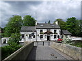
Ringley, Kearsley Hall Road
Ringley is a village on the east bank of the River Irwell near Kearsley. It is connected to Stoneclough across the River Irwell by the Grade II* listed Ringley Old Bridge which dates from the 17th century.
Image: © David Dixon
Taken: 15 Feb 2021
0.12 miles
2
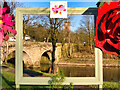
Framed! A Ringley View
A view of two of Ringley's 17th-century landmarks, Image] and Image], looking through the large (21st century) picture frame which has been constructed at the side of the river.
Image: © David Dixon
Taken: 15 Feb 2021
0.14 miles
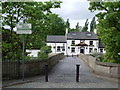
3
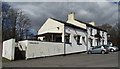
La Roma, Ringley
Italian restaurant previously The Lord Nelson pub.
Image: © philandju
Taken: 5 Apr 2013
0.14 miles
5
La Roma/Lord Nelson, Ringley
Formerly the Lord Nelson - a pub which served food. The pub has been re-named "La Roma" and the sign over the door declares it to now be a "restaurant and bar".
Image: © David Dixon
Taken: 29 Jan 2010
0.15 miles
6
Ringley Bridge and The Lord Nelson
Image: © Alexander P Kapp
Taken: 10 May 2007
0.15 miles
7
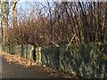
Heritage stone wall, Ringley Road
The use of large stone flags stood on end to make a wall is somewhat unusual, and characteristic in an area with abundant flaggy sandstones strata belonging to the Carboniferous. These are particularly fine examples, but have seen several replacements with lesser stones over the years. The rampant growth of Japanese Knotweed here is appalling.
Image: © Jonathan Wilkins
Taken: 26 Dec 2016
0.15 miles
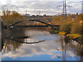
9
River Irwell at Ringley
Looking downstream from Ringley Old Bridge.
The bridge downstream used to carry pipes to the former Kearsley Power Station which was constructed in 1927 and was one of Britain's most efficient coal-fuelled generators. It was closed in 1980, and its cooling towers were demolished in 1985. The site has now been redeveloped for commerce and housing.
Image: © David Dixon
Taken: 5 Feb 2021
0.15 miles
10
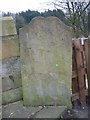
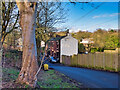
Old Boundary Marker by Ringley Old Bridge, Kearsley
Parish Boundary Marker by the UC road, in parish of Kearsley (Bolton District), Ringley Old Bridge, South of the A667 bridge.
Inscription reads:-
PARISH
PRESTWICH | DEAN
OUTWOOD | KERSLEY
Grade II listed.
List Entry Number: 1162452 https://historicengland.org.uk/listing/the-list/list-entry/1162452
Surveyed
Milestone Society National ID: LA_PRLRIN01pb
Image: © Milestone Society
Taken: Unknown
0.15 miles