IMAGES TAKEN NEAR TO
Fernside, MANCHESTER, M26 1EQ
Introduction
This page details the photographs taken nearby to Fernside, M26 1EQ by members of the Geograph project.
The Geograph project started in 2005 with the aim of publishing, organising and preserving representative images for every square kilometre of Great Britain, Ireland and the Isle of Man.

There are currently over 7.5m images from over14,400 individuals and you can help contribute to the project by visiting https://www.geograph.org.uk
Image Map (Loading...)


Getting Data...Please wait
Leaflet Map data © OpenStreetMap
Images are licensed for reuse under creativecommons.org/licenses/by-sa/2.0
Notes
- Clicking on the map will re-center to the selected point.
- The higher the marker number, the further away the image location is from the centre of the postcode.
Image Listing (16 Images Found)
Images are licensed for reuse under creativecommons.org/licenses/by-sa/2.0
Image
Details
Distance
2
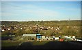
Stoneclough, Kearsley
Seen from a Preston to Manchester train.
Image: © Richard Sutcliffe
Taken: 25 Mar 2017
0.11 miles
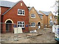
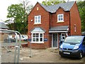
4
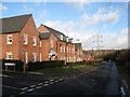
Kearsley Green
A new housing development upon the site of former industrial premises. The proximity of power distribution infrastructure is a ubiquitous feature of the district.
Image: © Jonathan Wilkins
Taken: 26 Dec 2016
0.12 miles
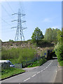
7
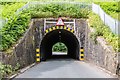
Kearsley Green
Road under the railway at Kearsley Green.
Image: © Peter McDermott
Taken: 23 Jun 2019
0.17 miles
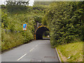
8

Low bridge, Hulme Road
Looking from Slackey Brow. The bridge carries the Bolton to Manchester railway line.
Image: © Bradley Michael
Taken: 24 Sep 2015
0.18 miles
9
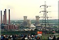
Demolition of Kearsley Cooling Towers - May 1985
Image: © Anthony Parkes
Taken: 12 May 1985
0.18 miles
10
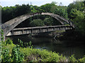
Kearsley - utility bridge over River Irwell
Image: © Dave Bevis
Taken: 21 May 2012
0.19 miles