IMAGES TAKEN NEAR TO
Hazel Grove, MANCHESTER, M26 1DD
Introduction
This page details the photographs taken nearby to Hazel Grove, M26 1DD by members of the Geograph project.
The Geograph project started in 2005 with the aim of publishing, organising and preserving representative images for every square kilometre of Great Britain, Ireland and the Isle of Man.

There are currently over 7.5m images from over14,400 individuals and you can help contribute to the project by visiting https://www.geograph.org.uk
Image Map
Images are licensed for reuse under creativecommons.org/licenses/by-sa/2.0
Notes
- Clicking on the map will re-center to the selected point.
- The higher the marker number, the further away the image location is from the centre of the postcode.
Image Listing (45 Images Found)
Images are licensed for reuse under creativecommons.org/licenses/by-sa/2.0
Image
Details
Distance
1
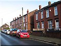
Elm Avenue, Outwood
Well-kept, red-brick terraced housing in this interesting and isolated outpost which seems a little odd until it is realised that it belongs to the long disused Outwood Colliery (abandoned in 1931, although the site was active until 1956 as a washery).
Image: © Jonathan Wilkins
Taken: 26 Dec 2016
0.05 miles
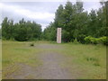
2
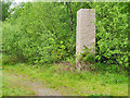
R?ckriem's Untitled Stones at Outwood Country Park
Famous German sculptor Ulrich Rückriem https://en.m.wikipedia.org/wiki/Ulrich_Ruckriem created one of his largest stone settings on the site of the former Outwood Colliery in 1999. The site of the former colliery consisted of 13 hectares of derelict land, collapsed buildings, spoil heaps, contaminated land and a number of uncapped mineshafts. Ownership of the site was transferred from British Coal Property to Bury Council in October 1997 with a view to reclaiming the land for public open space as part of the wider Outwood Forest Park project.
Rückriem’s complete work consists of ten large stone pieces set over a number of locations within the site; one column marks each of the two main entrances to the colliery and a group of seven tall slabs is installed on a flat plateau Image The largest slab Image], marks the line of the former railway track. This one is amongst the trees behind Sycamore Avenue. The complete work forms part of the Irwell Sculpture Trail.
Image: © David Dixon
Taken: 7 May 2020
0.07 miles
3
Outwood Forest Park
The site of the former Outwood colliery consisted of 13 hectares of derelict land, collapsed buildings, spoil heaps, contaminated land and a number of uncapped mineshafts. Ownership of the site was transferred from British Coal Property to Bury Council in October 1997 with a view to reclaiming the land for public open space as part of the wider Outwood Forest Park project.
The reclaimed land now provides a main gateway into the 80-hectare Outwood Forest Park and has a car park and footpaths; 25,000 trees have been planted. The park links with the Outwood Trail, the Irwell Sculpture Trail and the National Cycle Route and can accessed from Radcliffe by the recently restored Outwood Viaduct or from Ringley Road West at Outwood.
Image: © David Dixon
Taken: 25 Apr 2019
0.07 miles
4
Outwood Country Park
The site of the former Outwood colliery consisted of 13 hectares of derelict land, collapsed buildings, spoil heaps, contaminated land and a number of uncapped mineshafts. Ownership of the site was transferred from British Coal Property to Bury Council in October 1997 with a view to reclaiming the land for public open space as part of the wider Outwood Forest Park project.
The reclaimed land now provides a main gateway into the 80 hectare Outwood Forest Park and has a car park and footpaths; 25,000 trees have been planted. The park links with the Outwood Trail, the Irwell Sculpture Trail and the National Cycle Route and can accessed from Radcliffe by the recently restored Outwood Viaduct or from Ringley Road West at Outwood.
The park also provides a site for a major work of art as part of the Irwell Sculpture Trail. A number of large (up to 8 metres in height) stone settings by Ulrich Ruckriem are now in place on the former colliery site. (Image] and Image] )
(information from http://www.bury.gov.uk/index.aspx?articleid=5056 – Your Bury, a page which seems to have since been removed from the Bury MBC website)
Image: © David Dixon
Taken: 19 Jan 2012
0.08 miles
5
Irwell Sculpture Trail
One of Ulrich Ruckriems sculptures at Outwood. This one is hidden away in the small wooded area behind Elm Avenue.
Image: © Anthony Eyles
Taken: 3 Jun 2009
0.09 miles
6
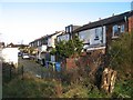
Backs, Elm Avenue
The backs of terraced houses can often make a more interesting image than the fronts. As always, the proliferation of wheelie-bins is evident. For a front view of Elm Avenue, see Image
Image: © Jonathan Wilkins
Taken: 26 Dec 2016
0.10 miles
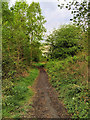
7
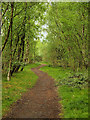
Clearing in Outwood Forest Park
The site of the former Outwood colliery consisted of 13 hectares of derelict land, collapsed buildings, spoil heaps, contaminated land and a number of uncapped mineshafts. Ownership of the site was transferred from British Coal Property to Bury Council in October 1997 with a view to reclaiming the land for public open space as part of the wider Outwood Forest Park project.
The reclaimed land now provides a main gateway into the 80-hectare Outwood Forest Park and has a car park and footpaths; 25,000 trees have been planted. The park links with the Outwood Trail, the Irwell Sculpture Trail and the National Cycle Route and can accessed from Radcliffe by the recently restored Outwood Viaduct or from Ringley Road West at Outwood.
Image: © David Dixon
Taken: 25 Apr 2019
0.10 miles
8
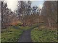
Outwood Country Park, A Choice of Paths
The site of the former Outwood colliery consisted of 13 hectares of derelict land, collapsed buildings, spoil heaps, contaminated land and a number of uncapped mineshafts. Ownership of the site was transferred from British Coal Property to Bury Council in October 1997 with a view to reclaiming the land for public open space as part of the wider Outwood Forest Park project.
The reclaimed land now provides a main gateway into the 80 hectare Outwood Forest Park and has a car park and footpaths; 25,000 trees have been planted. The park links with the Outwood Trail, the Irwell Sculpture Trail and the National Cycle Route and can accessed from Radcliffe by the recently restored Outwood Viaduct or from Ringley Road West at Outwood.
The park also provides a site for a major work of art as part of the Irwell Sculpture Trail. A number of large (up to 8 metres in height) stone settings by Ulrich Ruckriem are now in place on the former colliery site. (Image] and Image] )
(information from http://www.bury.gov.uk/index.aspx?articleid=5056 – Your Bury, a page which seems to have since been removed from the Bury MBC website)
Image: © David Dixon
Taken: 19 Jan 2012
0.12 miles
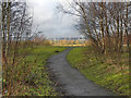
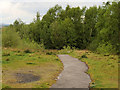
9
Path at Outwood Country Park
The site of the former Outwood colliery consisted of 13 hectares of derelict land, collapsed buildings, spoil heaps, contaminated land and a number of uncapped mineshafts. Ownership of the site was transferred from British Coal Property to Bury Council in October 1997 with a view to reclaiming the land for public open space as part of the wider Outwood Forest Park project.
The reclaimed land now provides a main gateway into the 80-hectare Outwood Forest Park and has a car park and footpaths; 25,000 trees have been planted. The park links with the Outwood Trail, the Irwell Sculpture Trail and the National Cycle Route and can accessed from Radcliffe by the recently restored Outwood Viaduct or from Ringley Road West at Outwood.
Image: © David Dixon
Taken: 25 Apr 2019
0.12 miles
10
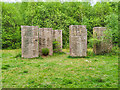
7 Steles, Irwell Sculpture Trail
Famous German sculptor Ulrich Rückriem https://en.m.wikipedia.org/wiki/Ulrich_Ruckriem created one of his largest stone settings on the site of the former Outwood Colliery in 1999. The site of the former colliery consisted of 13 hectares of derelict land, collapsed buildings, spoil heaps, contaminated land and a number of uncapped mineshafts. Ownership of the site was transferred from British Coal Property to Bury Council in October 1997 with a view to reclaiming the land for public open space as part of the wider Outwood Forest Park project.
Rückriem’s complete work consists of ten large stone pieces set over a number of locations within the site; one column marks each of the two main entrances to the colliery and this group of seven tall slabs is installed on a flat plateau. The largest slab Image], marks the line of the former railway track. The complete work forms part of the Irwell Sculpture Trail.
Image: © David Dixon
Taken: 7 May 2020
0.13 miles