IMAGES TAKEN NEAR TO
Bankfield Street, MANCHESTER, M26 1AS
Introduction
This page details the photographs taken nearby to Bankfield Street, M26 1AS by members of the Geograph project.
The Geograph project started in 2005 with the aim of publishing, organising and preserving representative images for every square kilometre of Great Britain, Ireland and the Isle of Man.

There are currently over 7.5m images from over14,400 individuals and you can help contribute to the project by visiting https://www.geograph.org.uk
Image Map
Images are licensed for reuse under creativecommons.org/licenses/by-sa/2.0
Notes
- Clicking on the map will re-center to the selected point.
- The higher the marker number, the further away the image location is from the centre of the postcode.
Image Listing (71 Images Found)
Images are licensed for reuse under creativecommons.org/licenses/by-sa/2.0
Image
Details
Distance
1
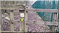
Manchester Bolton & Bury Canal pathway
This public footpath runs from the end of Fold Road to Red Rock Lane. United Utilities' water treatment plant is fenced off on the right hand side of the path. The route follows the plant around before heading through the garden of a house.
Image: © Bradley Michael
Taken: 10 Feb 2015
0.08 miles
4
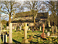
St Saviour's graveyard and Church, Ringley
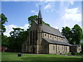
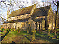
St Saviour's Church at Ringley is an active Anglican parish church. The present church, which dates from 1850-54 and is set well back from the road, is built in stone with ashlar dressings and has a stone slate roof. Its plan consists of a five-bay nave with a clerestory, north and south aisles, a north porch and a chancel with a south vestry. It has an octagonal turret, topped with a spire, at the southwest corner.
The church is recorded in the National Heritage List for England as a designated Grade II listed building (Historic England List Entry Number: 1067295 https://historicengland.org.uk/listing/the-list/list-entry/1067295 ). It is a commissioners' church, a grant of £200 having been provided by the Church Building Commissioners towards the cost of its construction.
The present church building is the third on the site. The first church was built in 1625. It was replaced in 1826 but this church wasn’t big enough and most of it was demolished in 1854, leaving just its tower. The new church was built in a position further back from the road, leaving the old tower isolated.
http://web.archive.org/web/20080509063934/http://www.mbbcanal.demon.co.uk/trail/clifton/ringpc/ringpc.html (Manchester, Bolton & Bury Canal Web Site, Ringley Parish Church archived 9th May 2008).
Image: © David Dixon
Taken: 29 Jan 2010
0.11 miles
5
St. Saviour's, Ringley
C. of E. church in the parish of Stoneclough.
Image: © philandju
Taken: 5 Apr 2013
0.12 miles
6
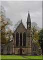
St Saviour, Ringley, the parish of Stoneclough
Image: © Ian Greig
Taken: 27 Oct 2016
0.12 miles
8
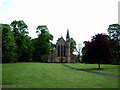
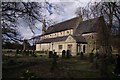
St Saviour's Church, Ringley
The south face of Saint Saviour's Church.
St Saviour's Church at Ringley is an active Anglican parish church. The present church, which dates from 1850-54 and is set well back from the road, is built in stone with ashlar dressings and has a stone slate roof. Its plan consists of a five-bay nave with a clerestory, north and south aisles, a north porch and a chancel with a south vestry. It has an octagonal turret, topped with a spire, at the southwest corner.
The church is recorded in the National Heritage List for England as a designated Grade II listed building (Historic England List Entry Number: 1067295 https://historicengland.org.uk/listing/the-list/list-entry/1067295 ). It is a commissioners' church, a grant of £200 having been provided by the Church Building Commissioners towards the cost of its construction.
The present church building is the third on the site. The first church was built in 1625. It was replaced in 1826 but this church wasn’t big enough and most of it was demolished in 1854, leaving just its tower. The new church was built in a position further back from the road, leaving the old tower isolated.
http://web.archive.org/web/20080509063934/http://www.mbbcanal.demon.co.uk/trail/clifton/ringpc/ringpc.html (Manchester, Bolton & Bury Canal Web Site, Ringley Parish Church archived 9th May 2008).
Image: © David Dixon
Taken: 29 Jan 2010
0.12 miles
9
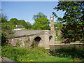
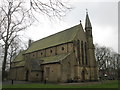
St Saviour tower and footbridge over River Irwell, Stoneclough
The footbridge over the River Irwell is a beautiful cobbled, pedestrian footbridge. It leads from the Lord Nelson public house on one side of the river to the Horseshoe public house on the other side. Both pubs are Thwaites pubs! St Saviour's church and the church clock tower are seen clearly on the O.S. map.
Image: © R Greenhalgh
Taken: 28 Apr 2007
0.13 miles