IMAGES TAKEN NEAR TO
Dale Street Industrial Estate, MANCHESTER, M26 1AD
Introduction
This page details the photographs taken nearby to Dale Street Industrial Estate, M26 1AD by members of the Geograph project.
The Geograph project started in 2005 with the aim of publishing, organising and preserving representative images for every square kilometre of Great Britain, Ireland and the Isle of Man.

There are currently over 7.5m images from over14,400 individuals and you can help contribute to the project by visiting https://www.geograph.org.uk
Image Map
Images are licensed for reuse under creativecommons.org/licenses/by-sa/2.0
Notes
- Clicking on the map will re-center to the selected point.
- The higher the marker number, the further away the image location is from the centre of the postcode.
Image Listing (372 Images Found)
Images are licensed for reuse under creativecommons.org/licenses/by-sa/2.0
Image
Details
Distance
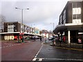
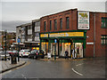
1
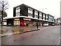
Bargain Booze
Dale Street precinct, Radcliffe.
Image: © David Dixon
Taken: 12 Nov 2012
0.01 miles
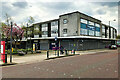
2
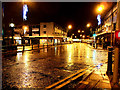
Dale Street
Looking along Dale Street from the corner of Blackburn Street. The piazza is across the road, on the left.
See also Image
Image: © David Dixon
Taken: 3 Dec 2011
0.02 miles

7
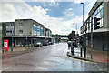
Empty Precinct
The 1960s concrete shopping precinct on Blackburn Street stands empty in readiness for the demolition work which is expected to begin in Summer 2023. There are plans to build a new "civic hub" on this site.
https://www.bury.gov.uk/planning-building-control/regeneration/radcliffe-regeneration/timeline Bury MBC Radcliffe Regeneration (archived 26 April 2023)
https://web.archive.org/web/20230308105808/https://www.placenorthwest.co.uk/radcliffe-unveils-40m-civic-hub-plans/ Place North West 7 March 2023 (archived 8 March 2023).
Image: © David Dixon
Taken: 26 Apr 2023
0.02 miles
8
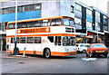
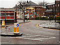
Blackburn Street/Church Street Junction (1982)
When the town centre bypass (Pilkington Way) was opened, this junction was closed as the bottom end of Blackburn Street was pedestrianised. It was partially re-opened (southbound only) in 2010, and a contemporary view can be seen at Image]
Image: © David Dixon
Taken: Unknown
0.02 miles
9
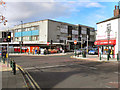
Blackburn Street/Church Street Junction (2010)
Since Image] was taken, the town centre bypass (Pilkington Way) was opened and the bottom end of Blackburn Street was pedestrianised. It has recently (2010) been partially reopened to southbound traffic as far as the piazza at Church Street.
Image: © David Dixon
Taken: 30 Oct 2010
0.02 miles
10
Homemakers, Radcliffe
The Homemakers DIY store at the corner of Blackburn Street and Railway Street. In the 1960s, this was a Woolworths store but it closed in the 1970s(?) and has been a DIY store for at least the last 30 years.
Image: © David Dixon
Taken: 30 Oct 2012
0.02 miles