IMAGES TAKEN NEAR TO
Farm Lane, MANCHESTER, M25 2RX
Introduction
This page details the photographs taken nearby to Farm Lane, M25 2RX by members of the Geograph project.
The Geograph project started in 2005 with the aim of publishing, organising and preserving representative images for every square kilometre of Great Britain, Ireland and the Isle of Man.

There are currently over 7.5m images from over14,400 individuals and you can help contribute to the project by visiting https://www.geograph.org.uk
Image Map
Images are licensed for reuse under creativecommons.org/licenses/by-sa/2.0
Notes
- Clicking on the map will re-center to the selected point.
- The higher the marker number, the further away the image location is from the centre of the postcode.
Image Listing (30 Images Found)
Images are licensed for reuse under creativecommons.org/licenses/by-sa/2.0
Image
Details
Distance
1
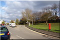
The end of the bus route
This turning circle enables the buses to turn round and commence the return journey. They wouldn't be able to get much further along Simister Lane.
Image: © Bill Boaden
Taken: 27 Mar 2010
0.04 miles
2
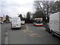
Bus turning circle, Simister
The turning circle opposite the Farmers Arms [sic] is a decent size, but proved very tricky to navigate (and photograph) on this occasion thanks to the proliferation of non buses in and around it. Rosso 171, a Dennis Dart SLF/Caetano Nimbus, has at least made it to the bus stop; it is single handedly operating the 90, shuttling between here and the Tesco superstore in Prestwich every 40 minutes. When I visited, this was also the terminus of the 96, an hourly service to Manchester via Bury New Road.
Image: © Richard Vince
Taken: 23 Apr 2016
0.04 miles
3
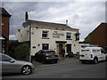
The Farmers Arms, Simister
A pub with an annoying lack of apostrophe, it proved difficult to photograph effectively thanks to the large number of parked vehicles around it. This was the best possible angle.
Image: © Richard Vince
Taken: 23 Apr 2016
0.06 miles
4
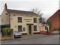
Farmers Arms
The Farmers Arms public house on Simister Lane.
Image: © David Dixon
Taken: 17 Feb 2012
0.06 miles
5
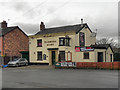
The Farmers Arms, Simister
The Farmers Arms on Simister Lane.
Image: © David Dixon
Taken: 17 Feb 2012
0.06 miles
6
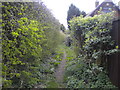
Public footpath off Simister Lane, Simister
A verdant path that looks inviting but meets the M60 motorway less than a quarter of a mile away.
Image: © Richard Vince
Taken: 23 Apr 2016
0.08 miles

8

St George's Church Simister
St George's Church, on Nutt Lane, a daughter church of Image] was opened on 14 October 1915. It was designed by R Basnett Preston in an unusual, austere, but very successful combination of Romanesque and vernacular revival styles; its austerity perhaps reflecting that it was begun and completed during the 1st World War. Prior to the building of St George’s the local people held services in the Simister Lane School, now The Lady Wilton Hall.
St George’s is a Grade II listed building (Historic England List Entry Number: 1350346 https://historicengland.org.uk/listing/the-list/list-entry/1350346 ).
Image: © David Dixon
Taken: 26 Feb 2021
0.14 miles
9
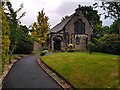
St George's
St George's Church in Simister.
Image: © Peter McDermott
Taken: 8 Jun 2020
0.14 miles
10

Slip Road M60/62 Junction 18
Traffic joining the M60 eastern section from a foggy M62 at junction 18, Simister Island.
Image: © David Dixon
Taken: 23 Jan 2010
0.15 miles