IMAGES TAKEN NEAR TO
Kielder Hill, MANCHESTER, M24 6TF
Introduction
This page details the photographs taken nearby to Kielder Hill, M24 6TF by members of the Geograph project.
The Geograph project started in 2005 with the aim of publishing, organising and preserving representative images for every square kilometre of Great Britain, Ireland and the Isle of Man.

There are currently over 7.5m images from over14,400 individuals and you can help contribute to the project by visiting https://www.geograph.org.uk
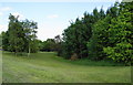
Image Map
Images are licensed for reuse under creativecommons.org/licenses/by-sa/2.0
Notes
- Clicking on the map will re-center to the selected point.
- The higher the marker number, the further away the image location is from the centre of the postcode.
Image Listing (13 Images Found)
Images are licensed for reuse under creativecommons.org/licenses/by-sa/2.0
Image
Details
Distance
1
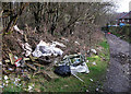
Fly tipping north of Middleton
This ought to be a pleasant lane linking Hollin Lane (A6046) to Rochdale Road (A664). At a point just to the east of The Queen Elizabeth School the lane is littered with this stuff. It is this anti-social behaviour that gives this part of Middleton a poor reputation.
Image: © michael ely
Taken: 15 Mar 2011
0.03 miles
2
Penrose Walk, Hollins
I found this estate annoying as there are no cut throughs between cul-de-sacs and you cannot join the footpath across the northern edge. I can see why the residents might welcome a restriction on people wandering through, but it limits them too.
Image: © Bill Boaden
Taken: 16 Jun 2010
0.07 miles
3
Byway south of St Anne's Academy
This route leads to the former Hopwood Hall estate
Image: © Kevin Waterhouse
Taken: 3 Dec 2022
0.08 miles
4
Tintern Road, Hollins
A large area of housing with both council and private.
Image: © Bill Boaden
Taken: 16 Jun 2010
0.14 miles
5

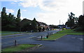
Sunset over Hazelhurst Drive
Looking West along Hazelhurst Drive, Middleton, Gtr Manchester.
Image: © Robert Graham Smith
Taken: 18 Aug 2003
0.14 miles
6
An area of green space in Hollins
This land is between Tintern Road and Whalley Road, around a small clough, and is entirely surrounded by housing.
Image: © Bill Boaden
Taken: 16 Jun 2010
0.16 miles
7
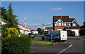
Hazlehurst Road, the entrance to St. Anne's Academy
With Willmott Dixon's contractor signs visible.
Image: © Steve Fareham
Taken: 26 Mar 2009
0.19 miles
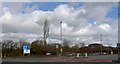
8

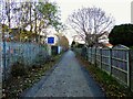
Segregated cycle lane on Hollin Lane (A6046)
Looking north west towards Junction 19 of the M62 Motorway.
Image: © JThomas
Taken: 25 Sep 2018
0.23 miles
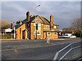
10
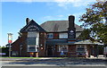
The Gardeners Arms
On Hollin Lane (A6046), Middleton.
Image: © JThomas
Taken: 25 Sep 2018
0.24 miles