IMAGES TAKEN NEAR TO
Long Street, MANCHESTER, M24 6DL
Introduction
This page details the photographs taken nearby to Long Street, M24 6DL by members of the Geograph project.
The Geograph project started in 2005 with the aim of publishing, organising and preserving representative images for every square kilometre of Great Britain, Ireland and the Isle of Man.

There are currently over 7.5m images from over14,400 individuals and you can help contribute to the project by visiting https://www.geograph.org.uk
Image Map
Images are licensed for reuse under creativecommons.org/licenses/by-sa/2.0
Notes
- Clicking on the map will re-center to the selected point.
- The higher the marker number, the further away the image location is from the centre of the postcode.
Image Listing (113 Images Found)
Images are licensed for reuse under creativecommons.org/licenses/by-sa/2.0
Image
Details
Distance
1
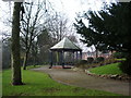
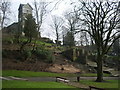
Bandstand, Jubilee Park, Middleton
Image: © Alexander P Kapp
Taken: 19 Feb 2008
0.07 miles
3
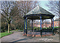
Bandstand in Jubilee Park, Middleton
This park is on the eastern side of Long Street (A664). The houses in the photo are on New Lane.
Image: © michael ely
Taken: 24 Mar 2011
0.08 miles
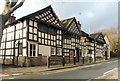
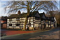
4
The Olde Boar's Head, Middleton
The Olde Boar's Head is a late-medieval public house and inn in Middleton, Greater Manchester, England. Situated below St Leonards, below the parish church, The Olde Boar's Head was originally a coaching inn on an ancient road between Chester and York. It is said to date from at least 1632, with parts from the 1500s.
Image: © Steven Haslington
Taken: 16 Nov 2011
0.09 miles
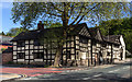
5
Olde Boar's Head, Middleton
Longstanding pub which has been in the Good Beer Guide.
Image: © Bill Boaden
Taken: 26 Dec 2012
0.09 miles
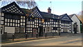
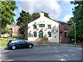
6
The Olde Boar's Head
The Olde Boar's Head on Long Street in Middleton.
Image: © Peter McDermott
Taken: 13 May 2018
0.09 miles
7
The Ring O'Bells, St Leonard's Square
The Ring o’ Bells is reputed to be one of the oldest buildings in Middleton; historically, the pub’s foundations are thought to date back to Saxon times.
The pub is said to be haunted by the ghost of a sad Cavalier known as Edward, and by poltergeists. According to "The Middleton Heritage Trail" leaflet (www.middleton-heritage-trail.org.uk ) the ghost is said to throw stones, glasses and other objects around the bar while its footsteps have been heard around the pub.
Image: © David Dixon
Taken: 14 Sep 2013
0.09 miles
8
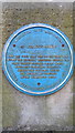
Blue Plaque for St Leonard's Square
A Blue Plaque supported by both the Middleton Civic Association and Rochdale Metropolitan Borough Council. The text reads as follows:
"St Leonard's Square
Once a focal point for the old town which before the Industrial Revolution occupied the ridge towards Rochdale. Nearby street names - High Street and Cheapside - identify the old town. Cottage silk weaving was practised in the surrounding area."
Image: © Steven Haslington
Taken: 16 Nov 2011
0.09 miles
10
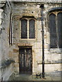
St Leonard's Parish Church, Middleton, Doorway
Image: © Alexander P Kapp
Taken: 19 Feb 2008
0.10 miles