Blue Plaque for St Leonard's Square
Introduction
The photograph on this page of Blue Plaque for St Leonard's Square by Steven Haslington as part of the Geograph project.
The Geograph project started in 2005 with the aim of publishing, organising and preserving representative images for every square kilometre of Great Britain, Ireland and the Isle of Man.

There are currently over 7.5m images from over 14,400 individuals and you can help contribute to the project by visiting https://www.geograph.org.uk
Blue Plaque for St Leonard's Square
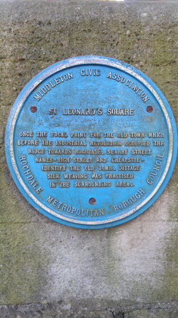
Image: © Steven Haslington Taken: 16 Nov 2011
A Blue Plaque supported by both the Middleton Civic Association and Rochdale Metropolitan Borough Council. The text reads as follows: "St Leonard's Square Once a focal point for the old town which before the Industrial Revolution occupied the ridge towards Rochdale. Nearby street names - High Street and Cheapside - identify the old town. Cottage silk weaving was practised in the surrounding area."
Images are licensed for reuse under creativecommons.org/licenses/by-sa/2.0
Image Location
Latitude
53.553439
Longitude
-2.194978