IMAGES TAKEN NEAR TO
Tennyson Road, MANCHESTER, M24 2NP
Introduction
This page details the photographs taken nearby to Tennyson Road, M24 2NP by members of the Geograph project.
The Geograph project started in 2005 with the aim of publishing, organising and preserving representative images for every square kilometre of Great Britain, Ireland and the Isle of Man.

There are currently over 7.5m images from over14,400 individuals and you can help contribute to the project by visiting https://www.geograph.org.uk
Image Map
Images are licensed for reuse under creativecommons.org/licenses/by-sa/2.0
Notes
- Clicking on the map will re-center to the selected point.
- The higher the marker number, the further away the image location is from the centre of the postcode.
Image Listing (15 Images Found)
Images are licensed for reuse under creativecommons.org/licenses/by-sa/2.0
Image
Details
Distance
1
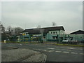
Boarshaw Community Primary School, Middleton
Image: © Alexander P Kapp
Taken: 25 Jan 2010
0.11 miles
2
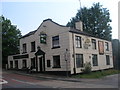
The Boarshaw
Public house on Stanycliffe Lane
Image: © David Dixon
Taken: 9 Feb 2010
0.14 miles
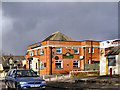
3
The Boarshaw, Stanycliffe Lane, Middleton
Image: © Alexander P Kapp
Taken: 25 Jan 2010
0.14 miles
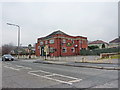
5
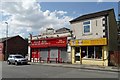
Business premises on Boarshaw Road, Middleton
"B RGAIN BOO" is a rather catchy shop name don't you think?
Image: © Neil Theasby
Taken: 24 Jul 2014
0.19 miles
7
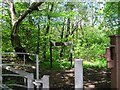
Hopwood Woods
This gateway leads into Hopwood Woods, a nature reserve, with many paths and streams. At this time of year there are quite a few bluebells, too.
Image: © Tricia Neal
Taken: 14 May 2014
0.22 miles
8
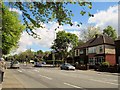
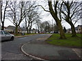
Rochdale Road, Hopwood
I was standing outside the entrance to Hopwood Woods, looking north along Rochdale Road. At the traffic lights, Stanycliffe Lane goes off to the right.
Image: © Tricia Neal
Taken: 14 May 2014
0.23 miles
9
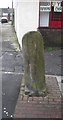
Old Milestone by the A664, Rochdale Road, Middleton
Carved stone post by the A664, in parish of MIDDLETON (ROCHDALE District), Rochdale Road junction with Vincent Street, next to bus stop and Black Bull, on East side of road. Erected by the Rochdale & Manchester, Manchester District turnpike trust in the 19th century.
Inscription once read:-
: (Rochdale / 5 : : Manchester / 7½) :
Milestone Society National ID: LA_RDMA05
Image: © M Faherty
Taken: 26 Jan 2009
0.23 miles