IMAGES TAKEN NEAR TO
Springs Road, MANCHESTER, M24 1QP
Introduction
This page details the photographs taken nearby to Springs Road, M24 1QP by members of the Geograph project.
The Geograph project started in 2005 with the aim of publishing, organising and preserving representative images for every square kilometre of Great Britain, Ireland and the Isle of Man.

There are currently over 7.5m images from over14,400 individuals and you can help contribute to the project by visiting https://www.geograph.org.uk
Image Map
Images are licensed for reuse under creativecommons.org/licenses/by-sa/2.0
Notes
- Clicking on the map will re-center to the selected point.
- The higher the marker number, the further away the image location is from the centre of the postcode.
Image Listing (58 Images Found)
Images are licensed for reuse under creativecommons.org/licenses/by-sa/2.0
Image
Details
Distance
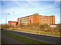
2
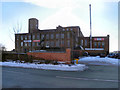
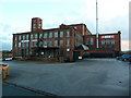
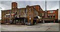
Swan Mill
Swan Mill, Foxdenton Lane, Middleton Junction.
Image: © David Dixon
Taken: 7 Dec 2010
0.11 miles
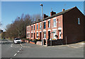
3
Swan Mill
Swan Mill, Foxdenton Lane, Middleton Junction.
Image: © David Dixon
Taken: 7 Dec 2010
0.11 miles
4
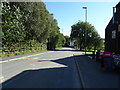
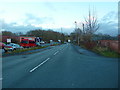
Foxdenton Lane, B6189
Looking towards Middleton. This terrace of houses is near the entrance to Ferney Field Farm.
Image: © michael ely
Taken: 18 Mar 2011
0.11 miles
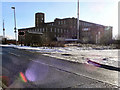
6
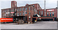
Swan Mill
Swan Mill at Middleton Junction.
Image: © Peter McDermott
Taken: 17 Oct 2014
0.11 miles
9
Swan Mill, Chadderton
Built in 1875, closed in 1959
Image: © Alexander P Kapp
Taken: 10 Feb 2009
0.13 miles
10
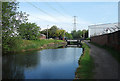
Rochdale Canal near Middleton Junction
Looking towards the Grimshaw Lane swing bridge.
Image: © michael ely
Taken: 16 May 2014
0.13 miles