IMAGES TAKEN NEAR TO
Millbrook Industrial Estate, Floats Road, MANCHESTER, M23 9WT
Introduction
This page details the photographs taken nearby to Millbrook Industrial Estate, Floats Road, M23 9WT by members of the Geograph project.
The Geograph project started in 2005 with the aim of publishing, organising and preserving representative images for every square kilometre of Great Britain, Ireland and the Isle of Man.

There are currently over 7.5m images from over14,400 individuals and you can help contribute to the project by visiting https://www.geograph.org.uk
Image Map
Images are licensed for reuse under creativecommons.org/licenses/by-sa/2.0
Notes
- Clicking on the map will re-center to the selected point.
- The higher the marker number, the further away the image location is from the centre of the postcode.
Image Listing (16 Images Found)
Images are licensed for reuse under creativecommons.org/licenses/by-sa/2.0
Image
Details
Distance
1

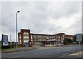
Southmoor House, Southmoor Road, Manchester
A 1930s block fronting Southmoor Industrial Estate. There is a further block to the right, Trafford House, and extensive sheds behind.
The tram runs in front.
Image: © Stephen Richards
Taken: 26 May 2016
0.15 miles

4
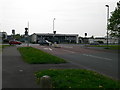
Southmoor Industrial Estate
Entrance off Southmoor Road.
Image: © Gerald England
Taken: 5 Sep 2016
0.18 miles
5
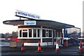
Gatehouse - Southmoor Industrial Estate
Image: © Anthony Parkes
Taken: 3 Jan 2014
0.19 miles
7
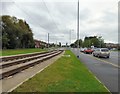
Southmoor Road
Running parallel is the Metrolink Tramway to Manchester Airport.
Image: © Gerald England
Taken: 5 Sep 2016
0.20 miles
8

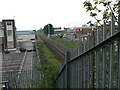
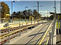
Metrolink Airport Line, Baguley Tram Stop
A Metrolink tram heads towards Manchester (Cornbrook) on the Airport line after leaving the inbound platform at Baguley Metrolink stop.
The tram route here runs along the eastern side of Southmoor Road; the Baguley stop is just south of the footpath from the western end of Glebelands Road and north of Floatshall Road. It has two facing platforms for inbound (towards Manchester) and outbound (towards Manchester Airport) trams. There are track-level pedestrian crossings at both ends of the station.
Image: © David Dixon
Taken: 3 Nov 2014
0.20 miles
9
Metrolink Airport Line, Baguley
The Baguley stop is on the eastern side of Southmoor Road, just south of the footpath from the western end of Glebelands Road and north of Floatshall Road. It has two facing platforms for inbound (towards Manchester) and outbound (towards Manchester Airport) trams. There are track-level pedestrian crossings at both ends of the station.
Image: © David Dixon
Taken: 3 Nov 2014
0.20 miles
10
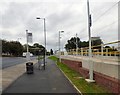
Southmoor Road
Bus stop outside Baguley tram stop.
Image: © Gerald England
Taken: 5 Sep 2016
0.20 miles