IMAGES TAKEN NEAR TO
Wythenshawe Road, MANCHESTER, M23 9DD
Introduction
This page details the photographs taken nearby to Wythenshawe Road, M23 9DD by members of the Geograph project.
The Geograph project started in 2005 with the aim of publishing, organising and preserving representative images for every square kilometre of Great Britain, Ireland and the Isle of Man.

There are currently over 7.5m images from over14,400 individuals and you can help contribute to the project by visiting https://www.geograph.org.uk
Image Map
Images are licensed for reuse under creativecommons.org/licenses/by-sa/2.0
Notes
- Clicking on the map will re-center to the selected point.
- The higher the marker number, the further away the image location is from the centre of the postcode.
Image Listing (22 Images Found)
Images are licensed for reuse under creativecommons.org/licenses/by-sa/2.0
Image
Details
Distance
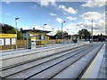
1
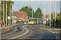
Through the esses
The tram has just departed from the Wythenshawe Park stop.
Image: © Alan Murray-Rust
Taken: 26 Oct 2015
0.06 miles
2
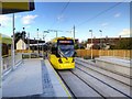
Metrolink Airport Line, Wythenshawe Park
Metrolink Bombardier M5000 tram number 3080 leaves the inbound platform of the Wythenshawe Park Metrolink stop, heading towards Manchester (Cornbrook).
The Wythenshawe Park tram stop is situated just off Wythenshawe Road, behind Bordley Walk, near to the Gardeners Arms public house. It has two facing platforms for inbound (towards Manchester) and outbound (towards Manchester Airport) trams. There is a track-level pedestrian crossing at each end.
Image: © David Dixon
Taken: 3 Nov 2014
0.07 miles
3
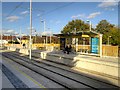
Manchester Airport Line, Wythenshawe Park Metrolink Stop
The Wythenshawe Park tram stop is situated just off Wythenshawe Road, behind Bordley Walk, near to the Gardeners Arms public house. It has two facing platforms for inbound (towards Manchester) and outbound (towards Manchester Airport) trams. There is a track-level pedestrian crossing at each end.
Image: © David Dixon
Taken: 3 Nov 2014
0.08 miles
4
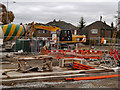
Metrolink Extension, Wythenshawe Park
Work on the Wythenshawe Park tram stop, next to Image This stop will be part of the Metrolink South Manchester Line Extension (phase 3b). This section of the tramway will run from St Werburgh's Road to Manchester Airport and is scheduled to open in 2016.
http://www.lrta.org/Manchester/airport.html LRT Association "Metrolink - Airport Line"
http://www.metrolink.co.uk/futuremetrolink/Pages/airport-line.aspx Transport for Greater Manchester - Metrolink Airport Line
Image: © David Dixon
Taken: 13 Nov 2012
0.08 miles
5
Wythenshawe Park Tram Stop, Metrolink Airport Line
The Wythenshawe Park tram stop is situated just off Wythenshawe Road, behind Bordley Walk, near to the Gardeners Arms public house. It has two facing platforms for inbound (towards Manchester) and outbound (towards Manchester Airport) trams. There is a track-level pedestrian crossing at each end.
Image: © David Dixon
Taken: 3 Nov 2014
0.08 miles
6
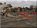
Site for Wythenshawe Park Metrolink Station
Work on the Wythenshawe Park tram stop, next to Image This stop will be part of the Metrolink South Manchester Line Extension (phase 3b). This section of the tramway will run from St Werburgh's Road to Manchester Airport and is scheduled to open in 2016.
http://www.lrta.org/Manchester/airport.html LRT Association "Metrolink - Airport Line"
http://www.metrolink.co.uk/futuremetrolink/Pages/airport-line.aspx Transport for Greater Manchester - Metrolink Airport Line
Image: © David Dixon
Taken: 13 Nov 2012
0.08 miles
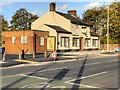
7
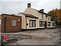
Gardeners Arms
The Gardeners Arms public house on Wythenshawe Road; next to Image
Image: © David Dixon
Taken: 13 Nov 2012
0.09 miles
8
Bordley Walk
The Metrolink line to Manchester Airport crosses Bordley Walk near the Wythenshawe Park tram stop.
Image: © David Dixon
Taken: 3 Nov 2014
0.09 miles
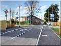
10
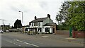
The Gardner's Arms
On Wythenshawe Road with the Metrolink tram station behind
Image: © Kevin Waterhouse
Taken: 2 May 2023
0.10 miles