IMAGES TAKEN NEAR TO
Brett Street, MANCHESTER, M22 4EY
Introduction
This page details the photographs taken nearby to Brett Street, M22 4EY by members of the Geograph project.
The Geograph project started in 2005 with the aim of publishing, organising and preserving representative images for every square kilometre of Great Britain, Ireland and the Isle of Man.

There are currently over 7.5m images from over14,400 individuals and you can help contribute to the project by visiting https://www.geograph.org.uk
Image Map
Images are licensed for reuse under creativecommons.org/licenses/by-sa/2.0
Notes
- Clicking on the map will re-center to the selected point.
- The higher the marker number, the further away the image location is from the centre of the postcode.
Image Listing (91 Images Found)
Images are licensed for reuse under creativecommons.org/licenses/by-sa/2.0
Image
Details
Distance
1
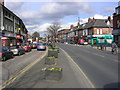
Palatine Road, Northenden
Looking toward junction with Brett Street ( the road joining from the right).
Image: © Keith Williamson
Taken: 2 Mar 2007
0.06 miles
2
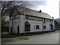
Tatton Arms Coach House
The two-storey coach house of the Tatton Arms Tavern, Boat Lane, Northenden. Now used as a theatre.
Image: © Keith Williamson
Taken: 2 Mar 2007
0.07 miles
3
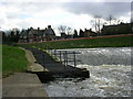
Salmon Ladder at Northenden
The salmon ladder at Northenden Weir (see Image)
Image: © Keith Williamson
Taken: 2 Mar 2007
0.07 miles
4
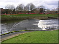
River Mersey at Northenden Weir and Salmon Ladder
Looking across the River Mersey from the Didsbury bank.
The Environment Agency constructed a fish pass here in 2003 to enable salmon and other fish to negotiate this previously impassable weir. This has resulted in salmon spawning in the upper reaches of the River Goyt (a tributary of the Mersey) on a regular basis. The fish pass runs under the gratings in front of the railings.(see Image). Also see (Image) for a view from the opposite bank after heavy rainfall.
Image: © Keith Williamson
Taken: 2 Mar 2007
0.07 miles
6
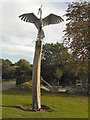
Heron Sculpture, Northernden Riverside Park
Image: © David Dixon
Taken: 27 Sep 2011
0.08 miles
7
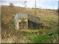
Mersey flood control and M60 embankment
The M60 Motorway crosses the floodplain of the River Mersey in the Northenden/Didsbury area to the south of Manchester. Sluice gates in the levees of the river allow controlled flooding and draining of a designated area. Tunnels such as the one pictured were built into the embankment of the motorway during its construction to enable passage of the flood waters.(see Image)
Image: © Keith Williamson
Taken: 2 Mar 2007
0.08 miles
8
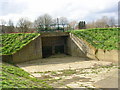
Mersey flood control
In the Didsbury/Northenden area high levees have been constructed to contain the River Mersey and prevent flooding. At times, however, it becomes necessary to flood designated areas hereabouts to stop the river over topping its banks or to control flooding further downstream. These sluice gates (and another set further upstream at Didsbury) control the water flow into and out of the flooded land at these times. ( See also Image)
Image: © Keith Williamson
Taken: 2 Mar 2007
0.08 miles
9
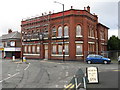
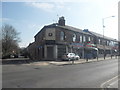
Northenden - The Church Inn
Disused pub at the confluence of Royle Green Road, Church Road and Ford Lane.
Image: © Peter Whatley
Taken: 23 Jan 2009
0.09 miles
10
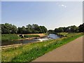
Northenden Weir
The weir on the River Mersey with the derelict Tatton Arms in the background.
Image: © Gerald England
Taken: 29 Jun 2019
0.09 miles