IMAGES TAKEN NEAR TO
High Lane, MANCHESTER, M21 9DL
Introduction
This page details the photographs taken nearby to High Lane, M21 9DL by members of the Geograph project.
The Geograph project started in 2005 with the aim of publishing, organising and preserving representative images for every square kilometre of Great Britain, Ireland and the Isle of Man.

There are currently over 7.5m images from over14,400 individuals and you can help contribute to the project by visiting https://www.geograph.org.uk
Image Map
Images are licensed for reuse under creativecommons.org/licenses/by-sa/2.0
Notes
- Clicking on the map will re-center to the selected point.
- The higher the marker number, the further away the image location is from the centre of the postcode.
Image Listing (70 Images Found)
Images are licensed for reuse under creativecommons.org/licenses/by-sa/2.0
Image
Details
Distance
1
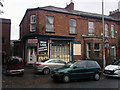
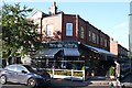
High Lane Grocers, Chorlton-cum-Hardy
This was previously a bike shop (during the 1980s at least). The Michelin Man stickers in the window date from that incarnation. Prior to that it was a grocers shop. Manchester Libraries have a photo showing how it used to look. http://www.images.manchester.gov.uk/web/objects/common/webmedia.php?irn=38745
The police raided the property in 2009 following a tip off and recovered a large number of stolen items. http://menmedia.co.uk/manchestereveningnews/news/s/1311722_community_order_for_handling_stolen_goods_
Image: © Phil Champion
Taken: 23 Oct 2010
0.02 miles
2
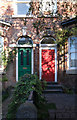
Coloured doors
Victorian houses, and one of these doors looks original. I just like the colours of the woodwork and the bricks.
Image: © Bob Harvey
Taken: 17 Sep 2019
0.09 miles
3
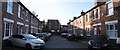
Hardy Avenue
A cul-de-sac of Terraced Houses.
Image: © Bob Harvey
Taken: 17 Sep 2019
0.09 miles
4
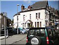
Chorlton cum Hardy
Dental surgery on the corner of Groby Road and Manchester Road.
Image: © Gerald England
Taken: 22 Apr 2010
0.11 miles
5
Laundrette
I have no idea if this is a former laundrette. But what it is now is a bistro called "Laundrette".
(I bet you it was one, though).
Image: © Bob Harvey
Taken: 17 Sep 2019
0.11 miles
6
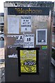
Community use
This phone box is still in use as a phone box, but the back is used in a subculture way, even down to a vulgar but quite telling poem.
Image: © Bob Harvey
Taken: 17 Sep 2019
0.12 miles
7
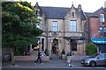
The Lead Station
Former police station, now a pub.
The web site says it is a bar and bistro, but I know a pub when I see one. It's a pub
Image: © Bob Harvey
Taken: 17 Sep 2019
0.13 miles
8
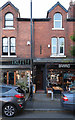
Truth and Barrio
A lot of effort and creativity has gone into the small shops in Beech Road, Chorlton
Image: © Bob Harvey
Taken: 17 Sep 2019
0.13 miles
9
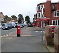
On the corner of Barlow Moor Road and Groby Road
Barlow Moor Road is the B5217 through Chorlton cum Hardy. On the corner is Bridgfords estate agents and an EIIR postbox (M21 667).
Image: © Gerald England
Taken: 1 Oct 2016
0.13 miles
10
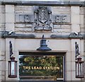
Datestone
Above the door of Image (the former police station) is the date 1885. As I asked my way around town that date came up over and over again. There must have been a lot of building round here in 1885
Image: © Bob Harvey
Taken: 17 Sep 2019
0.13 miles