IMAGES TAKEN NEAR TO
Dartmouth Road, MANCHESTER, M21 8XJ
Introduction
This page details the photographs taken nearby to Dartmouth Road, M21 8XJ by members of the Geograph project.
The Geograph project started in 2005 with the aim of publishing, organising and preserving representative images for every square kilometre of Great Britain, Ireland and the Isle of Man.

There are currently over 7.5m images from over14,400 individuals and you can help contribute to the project by visiting https://www.geograph.org.uk
Image Map (Loading...)


Getting Data...Please wait
Leaflet Map data © OpenStreetMap
Images are licensed for reuse under creativecommons.org/licenses/by-sa/2.0
Notes
- Clicking on the map will re-center to the selected point.
- The higher the marker number, the further away the image location is from the centre of the postcode.
Image Listing (107 Images Found)
Images are licensed for reuse under creativecommons.org/licenses/by-sa/2.0
Image
Details
Distance
2
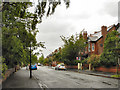
Warning notices alongside Metrolink worksite
Work was underway on the Metrolink extension to St Werburgh's Road, utilising the disused railway line.
Image: © Phil Champion
Taken: 29 Aug 2009
0.07 miles
3
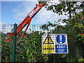
Crane on disused railway line north west of Chorlton Junction
The former railway line, which closed in 1988, is to be re-opened as part of the Metrolink tram network.
Image: © Phil Champion
Taken: 29 Aug 2009
0.07 miles
4

Street art on fence beside disused railway line
Image: © Phil Champion
Taken: 29 Aug 2009
0.07 miles
6
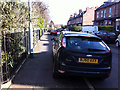
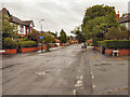
Pavement parking on Sandy Lane, Chorlton
An inconsiderately parked Ford Focus taking up almost half the footway.
Highway Code rule 244:
"You MUST NOT park partially or wholly on the pavement in London, and should not do so elsewhere unless signs permit it. Parking on the pavement can obstruct and seriously inconvenience pedestrians, people in wheelchairs or with visual impairments and people with prams or pushchairs".
Image: © Phil Champion
Taken: 5 Mar 2012
0.08 miles
8
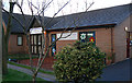
Pentecostal Church and Nursery, Sandy Lane, Chorlton
This used to be the site of Chorlton Grammar School which I attended in the 1950s. This pentecostal church is obviously new. There is also a Lighthouse Childcare centre attached. The school had moved to a new site nearby Image
Image: © John Rostron
Taken: 7 Dec 2011
0.09 miles
9
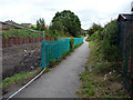
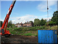
Fallowfield Loop Cycleway
Looking along the line of the disused railway line towards Chorlton Junction from the start of the route near Sidbury Road. The cycleway, developed in the late 1990s, is to be realigned to cross the tracks and run along the north side to accommodate the planned extension to the Metrolink network to St Werburgh's Road. Work had already commenced to clear the line and widen the cutting.
Image: © Phil Champion
Taken: 29 Aug 2009
0.10 miles
10
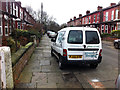
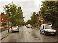
Brookfield Avenue, Chorlton
The width of this cul-de-sac, and the numbers of cars owned by the occupants is such, that most drivers here park with two wheels on the kerb. The driver of this van has parked it a little further onto the pavement than most.
Image: © Phil Champion
Taken: 27 Feb 2012
0.10 miles