IMAGES TAKEN NEAR TO
Nell Lane, MANCHESTER, M21 8UE
Introduction
This page details the photographs taken nearby to Nell Lane, M21 8UE by members of the Geograph project.
The Geograph project started in 2005 with the aim of publishing, organising and preserving representative images for every square kilometre of Great Britain, Ireland and the Isle of Man.

There are currently over 7.5m images from over14,400 individuals and you can help contribute to the project by visiting https://www.geograph.org.uk
Image Map
Images are licensed for reuse under creativecommons.org/licenses/by-sa/2.0
Notes
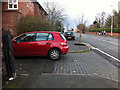
- Clicking on the map will re-center to the selected point.
- The higher the marker number, the further away the image location is from the centre of the postcode.
Image Listing (132 Images Found)
Images are licensed for reuse under creativecommons.org/licenses/by-sa/2.0
Image
Details
Distance
1
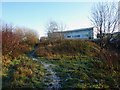
Footpath through the Clough, Chorlton-cum-Hardy
The buildings are at Chorlton High School, on the opposite side of Chorlton Brook. The path leads from Nell Lane to Mauldeth Road West at Twenty-seven steps.
Image: © Phil Champion
Taken: 18 Dec 2011
0.03 miles
2
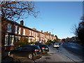
Nell Lane, Chorlton-cum-Hardy
Looking up the slight hill towards the junction with St Weburgh's Road and Sandy Lane. Behind the photographer's position Nell Lane crosses Houghend Bridge, by the corner of Chorlton Park.
Image: © Phil Champion
Taken: 18 Dec 2011
0.04 miles
3
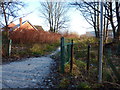
Footpath off Nell Lane
From Nell Lane a path follows Chorlton Brook along 'the Clough' towards Mauldeth Road West. The buildings of Chorlton High School, on the other side of the brook, can just be made out in the distance.
Image: © Phil Champion
Taken: 18 Dec 2011
0.04 miles
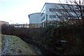
4
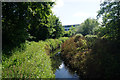
Chorlton Brook
There is a glimpse of Chorlton High School behind.
Image: © Bill Boaden
Taken: 10 Jun 2015
0.04 miles
5
St Werburgh's Road, Chorlton
Looking north in the direction of the tram stop. The building on the left is converted barn at Park Brow Farm.
Image: © Phil Champion
Taken: 17 Mar 2012
0.05 miles
6
Chorlton Brook at the rear of Chorlton High School
A footpath follows the brook through the Clough. The main part of the school site is on the south side of the brook, with sports pitches on the north side.
Image: © Phil Champion
Taken: 18 Dec 2011
0.05 miles
7
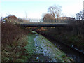
Bridge across Chorlton Brook at the rear of Chorlton High School
The rear of the school site is bordered by the brook, with land on the opposite bank being used as playing fields. When Chorlton High School was amalgamated onto a single site a few years earlier, new buildings were erected with a bridge to link to the playing fields, avoiding the need to leave the site and cross the brook at Hough End Bridge on Nell Lane. A public footpath runs beneath the bridge.
Image: © Phil Champion
Taken: 18 Dec 2011
0.07 miles
8
Chorlton High School from Nell Lane
Having attended Chorlton Grammar School in Sandy Lane in the 1950s, I took the opportunity to find it again. The original site was occupied by a Pentecostal Church Image, and the school had relocated to the other side of Chorlton Park.
Image: © John Rostron
Taken: 7 Dec 2011
0.08 miles
9
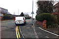
St Werburgh's Road, Chorlton
Looking towards the railway bridge. The double yellow lines here were added around the time the nearby Metrolink stop was opened in July 2011.
The Mercedes van with its wheels up on the footway was probably making a delivery to a nearby house.
Image: © Phil Champion
Taken: 27 Feb 2012
0.08 miles
10
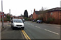
St Werburgh's Road, Chorlton
The double yellow lines here were added around the time the nearby Metrolink stop was opened in July 2011.
The Mercedes van with its wheels up on the footway was probably making a delivery to a nearby house.
The buildings on the right are the former farmhouse and a barn at Park Brow Farm, converted to dwellings in the late 1980s or early 1990s.
Image: © Phil Champion
Taken: 27 Feb 2012
0.08 miles