IMAGES TAKEN NEAR TO
Brassington Avenue, MANCHESTER, M21 8FY
Introduction
This page details the photographs taken nearby to Brassington Avenue, M21 8FY by members of the Geograph project.
The Geograph project started in 2005 with the aim of publishing, organising and preserving representative images for every square kilometre of Great Britain, Ireland and the Isle of Man.

There are currently over 7.5m images from over14,400 individuals and you can help contribute to the project by visiting https://www.geograph.org.uk
Image Map
Images are licensed for reuse under creativecommons.org/licenses/by-sa/2.0
Notes
- Clicking on the map will re-center to the selected point.
- The higher the marker number, the further away the image location is from the centre of the postcode.
Image Listing (68 Images Found)
Images are licensed for reuse under creativecommons.org/licenses/by-sa/2.0
Image
Details
Distance
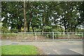
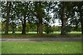
3
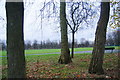
Chorlton Park
A pleasant area of green space largely given over to playing fields.
Image: © Bill Boaden
Taken: 7 Dec 2013
0.10 miles
6

Tram on Hardy Lane
The new route to Manchester Airport includes several sections where trams use traditional street track.
Image: © Alan Murray-Rust
Taken: 26 Oct 2015
0.12 miles
7
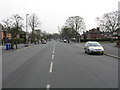
Pavement parking on Hardy Lane, Chorlton
Despite the unusual width of Hardy Lane, many of the residents feel a need to park on the footways.
In the 1920s Hardy Lane was narrow country lane leading from Barlow Moor Road to Hardy Farm, with a continuation as a footpath to the footbridge over the Mersey at Jacksons Boat. Council housing estates were constructed to the south of Barlow Moor Road in the late 1920s / early 1930s, and Hardy Lane was substantially widened, with a new dual carriageway being constructed from its north end. It was envisaged that Hardy lane would be extended across the river to join up with Old Hall Lane in Sale. This Hardy Lane Extension was never built, although it was shown on maps right up to the 1980s, and the nearby motorway junction was laid out with it in mind.
Image: © Phil Champion
Taken: 18 Dec 2011
0.13 miles
8
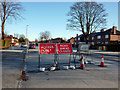
Road closure signs on Hardy Lane, Chorlton
The planned extension of the Metrolink network to Manchester Airport will see trams running along the centre of Mauldeth Road West and Hardy Lane, continuing to a river crossing near Jacksons Boat. The line is scheduled to open in 2016. When this photo was taken works were ongoing to divert utilities at the junction of Hardy Lane and Barlow Moor Road. This entailed Hardy Lane being closed off at that point. Traffic was being diverted along Cundiff Road, where a point closure near Barlow Moor Road had been temporarily removed.
Image: © Phil Champion
Taken: 18 Dec 2011
0.13 miles
9
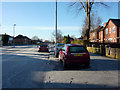
Pavement parking on Hardy Lane, Chorlton
Despite the unusual width of Hardy Lane, many of the residents feel a need to park on the footways.
In the 1920s Hardy Lane was narrow country lane leading from Barlow Moor Road to Hardy Farm, with a continuation as a footpath to the footbridge over the Mersey at Jacksons Boat. Council housing estates were constructed to the south of Barlow Moor Road, and Hardy Lane was substantially widened, with a new dual carriageway being constructed from its north end. It was envisaged that Hardy lane would be extended across the river to join up with Old Hall Lane in Sale. This Hardy Lane Extension was never built, although it was shown on maps right up to the 1980s, and the nearby motorway junction was laid out with it in mind.
Image: © Phil Champion
Taken: 18 Dec 2011
0.13 miles
10
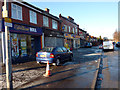
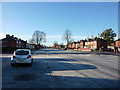
Shops on Barlow Moor Road, Chorlton
On the south west side of the junction with Mauldeth Road West and Hardy Lane. These shops, along with the nearby council estates which stretch all along the south side of Barlow Moor Road, were built in the 1920s. Look beyond the tatty modern shop fronts and note the interesting classical detailing above an ordinary, but pleasingly symmetrical, row of shops.
Image: © Phil Champion
Taken: 18 Dec 2011
0.13 miles