IMAGES TAKEN NEAR TO
Barlow Moor Road, MANCHESTER, M21 8AN
Introduction
This page details the photographs taken nearby to Barlow Moor Road, M21 8AN by members of the Geograph project.
The Geograph project started in 2005 with the aim of publishing, organising and preserving representative images for every square kilometre of Great Britain, Ireland and the Isle of Man.

There are currently over 7.5m images from over14,400 individuals and you can help contribute to the project by visiting https://www.geograph.org.uk
Image Map
Images are licensed for reuse under creativecommons.org/licenses/by-sa/2.0
Notes
- Clicking on the map will re-center to the selected point.
- The higher the marker number, the further away the image location is from the centre of the postcode.
Image Listing (80 Images Found)
Images are licensed for reuse under creativecommons.org/licenses/by-sa/2.0
Image
Details
Distance
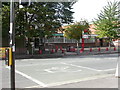
2
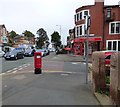
On the corner of Barlow Moor Road and Groby Road
Barlow Moor Road is the B5217 through Chorlton cum Hardy. On the corner is Bridgfords estate agents and an EIIR postbox (M21 667).
Image: © Gerald England
Taken: 1 Oct 2016
0.04 miles
3
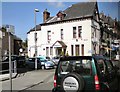
Chorlton cum Hardy
Dental surgery on the corner of Groby Road and Manchester Road.
Image: © Gerald England
Taken: 22 Apr 2010
0.05 miles
5
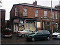
High Lane Grocers, Chorlton-cum-Hardy
This was previously a bike shop (during the 1980s at least). The Michelin Man stickers in the window date from that incarnation. Prior to that it was a grocers shop. Manchester Libraries have a photo showing how it used to look. http://www.images.manchester.gov.uk/web/objects/common/webmedia.php?irn=38745
The police raided the property in 2009 following a tip off and recovered a large number of stolen items. http://menmedia.co.uk/manchestereveningnews/news/s/1311722_community_order_for_handling_stolen_goods_
Image: © Phil Champion
Taken: 23 Oct 2010
0.10 miles
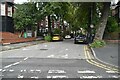
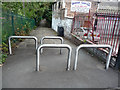
6
Wilbraham Road from cycle path next to Bridge Garage
Image: © Phil Champion
Taken: 29 Aug 2009
0.10 miles
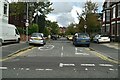
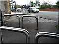
7
Chicane on cycle path by Bridge Garage
The disused railway line is behind the fence on the left. Wilbraham Road is to the rear of the photographer's position.
Image: © Phil Champion
Taken: 29 Aug 2009
0.10 miles
8
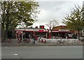
Chorlton Village Post Office
The post office and the Post Box Café on Wilbraham Road.
Image: © Gerald England
Taken: 28 Apr 2014
0.10 miles
9
Chorlton Post Office
On Wilbraham Road.
Image: © Mike Faherty
Taken: 29 Aug 2009
0.11 miles
10
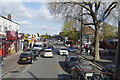
Wilbraham Road, Chorlton
Looking east towards the junction with Albany and Corkland Roads from the top deck of the 85 bus. The white buildings on the left were once private residence with long front gardens, before the addition of single storey shops in front.
Image: © Phil Champion
Taken: 19 Apr 2014
0.11 miles