IMAGES TAKEN NEAR TO
Pinetop Close, MANCHESTER, M21 7RN
Introduction
This page details the photographs taken nearby to Pinetop Close, M21 7RN by members of the Geograph project.
The Geograph project started in 2005 with the aim of publishing, organising and preserving representative images for every square kilometre of Great Britain, Ireland and the Isle of Man.

There are currently over 7.5m images from over14,400 individuals and you can help contribute to the project by visiting https://www.geograph.org.uk
Image Map
Images are licensed for reuse under creativecommons.org/licenses/by-sa/2.0
Notes
- Clicking on the map will re-center to the selected point.
- The higher the marker number, the further away the image location is from the centre of the postcode.
Image Listing (31 Images Found)
Images are licensed for reuse under creativecommons.org/licenses/by-sa/2.0
Image
Details
Distance
1
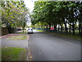
South end of Arrowfield Road, Chorlton
Seen from close to the junction with Nell Lane, with part of Manchester Southern Cemetery on the right.
Image: © Richard Vince
Taken: 12 May 2018
0.10 miles
2
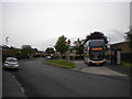
Arrowfield Road bus terminus, Chorlton
Stagecoach Manchester 10422, an Alexander Dennis Enviro 400MMC, stands in the turning circle built into the junction with Wintermans Road before working an 85 to Manchester city centre via Chorlton bus station and Whalley Range.
Image: © Richard Vince
Taken: 12 May 2018
0.10 miles
3
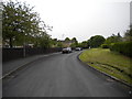
Southern part of Wintermans Road, Chorlton
Image: © Richard Vince
Taken: 12 May 2018
0.15 miles
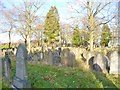
4
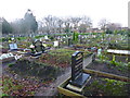
Manchester Southern Cemetery
The Muslim section: http://www.manchester.gov.uk/info/200032/deaths_funerals_and_cemeteries/5099/manchester_cemeteries_and_crematorium/5
Image: © Mike Faherty
Taken: 25 Dec 2014
0.16 miles
6
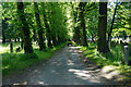
Avenue in Southern Cemetery
Enabling the staff to get around.
Image: © Bill Boaden
Taken: 10 Jun 2015
0.19 miles
7
Manchester Southern Cemetery
The older, Victorian part at http://www.manchester.gov.uk/info/200032/deaths_funerals_and_cemeteries/5099/manchester_cemeteries_and_blackley_crematorium/5
Image: © Mike Faherty
Taken: 25 Dec 2014
0.19 miles
8
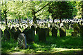
Sunlight on gravestones in Southern Cemetery
Image: © Bill Boaden
Taken: 10 Jun 2015
0.19 miles
9
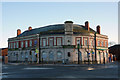
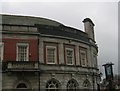
The Southern Hotel, Chorlton
This substantial public house was built in the 1920s at the corner of Mauldeth Road West and Nell Lane. For a number of years the pub had had an Irish theme (there being a large Irish population in the area). According to the signs the building also housed 'Mammy's Irish Kitchen'(a cafe) and the Celtic Tiger nightclub (offering live Irish music). The Southern closed in April 2011 and as of December 2011 was still boarded up and up for sale.
Image: © Phil Champion
Taken: 18 Dec 2011
0.20 miles
10
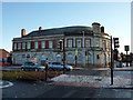
The Southern Hotel, Mauldeth Road West, Chorlton
This substantial public house was built in the 1920s at the corner of Mauldeth Road West and Nell Lane. For a number of years the pub had had an Irish theme (there being a large Irish population in the area). According to the signs the building also housed 'Mammy's Irish Kitchen' (a cafe) and the Celtic Tiger nightclub (offering live Irish music). The Southern closed in April 2011 and as of December 2011 was still boarded up and up for sale.
Image: © Phil Champion
Taken: 18 Dec 2011
0.20 miles