IMAGES TAKEN NEAR TO
Mellowstone Drive, MANCHESTER, M21 7RJ
Introduction
This page details the photographs taken nearby to Mellowstone Drive, M21 7RJ by members of the Geograph project.
The Geograph project started in 2005 with the aim of publishing, organising and preserving representative images for every square kilometre of Great Britain, Ireland and the Isle of Man.

There are currently over 7.5m images from over14,400 individuals and you can help contribute to the project by visiting https://www.geograph.org.uk
Image Map
Images are licensed for reuse under creativecommons.org/licenses/by-sa/2.0
Notes
- Clicking on the map will re-center to the selected point.
- The higher the marker number, the further away the image location is from the centre of the postcode.
Image Listing (20 Images Found)
Images are licensed for reuse under creativecommons.org/licenses/by-sa/2.0
Image
Details
Distance
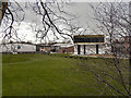
1

Princess Road - Mauldeth Road Junction at Hough End
Corner of Hough End playing fields at the junction of Princess Road and Mauldeth Road, looking west. 27 football pitches cover a large open area - it used to be the site of Alexandra Park aerodrome from which UK's first domestic air service to Southport and Blackpool commenced on 24th May 1919.
Image: © Karel Hladky
Taken: 7 Jun 2004
0.08 miles
3
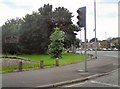
Hough End Fields
At the corner of Princess Road and Mauldeth Road West.
Image: © Gerald England
Taken: 21 Jul 2012
0.10 miles
4
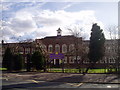
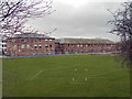
Whalley Range Girls High School
Situated on the junction of Wilbraham Road and Princess Road, Whalley Range Girls High School serves the Manchester areas of Whalley Range and Moss Side.
Image: © R Greenhalgh
Taken: 7 Mar 2008
0.14 miles
5
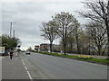
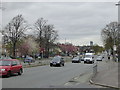
The A5103 Princess Road at Whalley Range
Looking south.
Image: © Rod Allday
Taken: 12 Apr 2014
0.14 miles
7
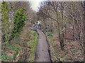
Cycleway
Cycleway along the course of the former railway line. Viewed from Alexandra Road South.
Image: © David Dixon
Taken: 7 Jan 2012
0.16 miles
8
The A5103 Princess Road at Whalley Range
Looking north.
Image: © Rod Allday
Taken: 12 Apr 2014
0.17 miles
9
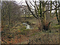
Hough End Clough, Red Lion Brook
It appears that the Clough is the last remnant of an ancient wood. The 1848 OS map shows that Chorlton Brook was well wooded on both banks at that time, from its present eastern limit up to Hough End Bridge (Nell Lane). Hough End Hall, which was built in 1596, was named after the Clough; evidence of the age and importance of the wood. (taken from an information board next to the path through the Clough)
Image: © David Dixon
Taken: 7 Jan 2012
0.17 miles
10
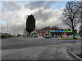
Mauldeth Road West
Filling station on the corner of Mauldeth Road West and Alexandra Road South
Image: © David Dixon
Taken: 7 Jan 2012
0.18 miles