IMAGES TAKEN NEAR TO
Aldermary Road, MANCHESTER, M21 7QN
Introduction
This page details the photographs taken nearby to Aldermary Road, M21 7QN by members of the Geograph project.
The Geograph project started in 2005 with the aim of publishing, organising and preserving representative images for every square kilometre of Great Britain, Ireland and the Isle of Man.

There are currently over 7.5m images from over14,400 individuals and you can help contribute to the project by visiting https://www.geograph.org.uk
Image Map
Images are licensed for reuse under creativecommons.org/licenses/by-sa/2.0
Notes
- Clicking on the map will re-center to the selected point.
- The higher the marker number, the further away the image location is from the centre of the postcode.
Image Listing (96 Images Found)
Images are licensed for reuse under creativecommons.org/licenses/by-sa/2.0
Image
Details
Distance
1
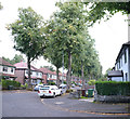
Aldermary Road
Another tree lined avenue
Image: © Bob Harvey
Taken: 10 Sep 2019
0.02 miles
2
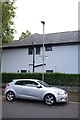
Elevated road name
The road names on this estate are mounted high on lampposts. This one is for Callingdon Street.
The house behind is recently modernised, with a painted rendered surface that was once brick.
Image: © Bob Harvey
Taken: 10 Sep 2019
0.02 miles
4
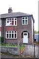
Decorative windows
This house in Leacroft Road has retained the horseshoe porch it was built with, and most of the decorative leaded glazing in the bay windows, but has augmented them with a rural scene in the window above the front door, unique along this road.
Image: © Bob Harvey
Taken: 10 Sep 2019
0.06 miles
5

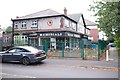
Closed down
The shopfront, and appeal to use their Moston branch, at Image
Image: © Bob Harvey
Taken: 10 Sep 2019
0.06 miles
6
Former monumental mason
This stretch of Barlow Moor Road had at least half a dozen monumental masons, serving the vast cemetery across the road. This was the largest, but is now closed.
I understand that they did not adapt well to the changing population, not being able to offer Urdu, Hindi, or Arabic inscriptions.
See Image for a thriving competitor in the same block.
Image: © Bob Harvey
Taken: 10 Sep 2019
0.07 miles
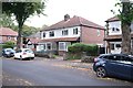
7
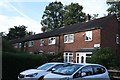
Derwent Close
A 1940s terrace off Derwent Avenue
Image: © Bob Harvey
Taken: 10 Sep 2019
0.07 miles
8
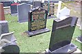
Display of gravestones
Outside Image are several examples of their work. I think we see here an indication of the successes of integration; an indigenous tradition fully adapted to the needs of an incoming population, and an indication of why integration can work - we are all born, die, and love our families.
I often wonder about such displays. The stones with finished inscriptions cannot be for sale, perhaps they are awaiting delivery. The central one here may have been rejected, or be waiting for a new plinth, which is inscribed "forever in our herts"
Image: © Bob Harvey
Taken: 10 Sep 2019
0.07 miles
9
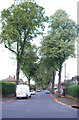
Aldermary Road
Tree-lined suburban street in Barlow Moor
Image: © Bob Harvey
Taken: 10 Sep 2019
0.07 miles
10

Pillar Box
One of King George's. There is no Regnal number on the Cypher, so it is almost certainly King George V.
The box is identified on the plaque as M21 695D
Image: © Bob Harvey
Taken: 10 Sep 2019
0.08 miles