IMAGES TAKEN NEAR TO
Wyverne Road, MANCHESTER, M21 0ZW
Introduction
This page details the photographs taken nearby to Wyverne Road, M21 0ZW by members of the Geograph project.
The Geograph project started in 2005 with the aim of publishing, organising and preserving representative images for every square kilometre of Great Britain, Ireland and the Isle of Man.

There are currently over 7.5m images from over14,400 individuals and you can help contribute to the project by visiting https://www.geograph.org.uk
Image Map
Images are licensed for reuse under creativecommons.org/licenses/by-sa/2.0
Notes
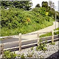
- Clicking on the map will re-center to the selected point.
- The higher the marker number, the further away the image location is from the centre of the postcode.
Image Listing (76 Images Found)
Images are licensed for reuse under creativecommons.org/licenses/by-sa/2.0
Image
Details
Distance
4
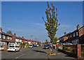
Withington Road - Chorlton-cum-Hardy
Image: © Anthony Parkes
Taken: 14 Mar 2012
0.15 miles
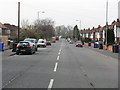
5
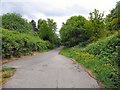
Fallowfield Loop
The start of the Fallowfield Loop at St Werbergh's Road.
Image: © Gerald England
Taken: 1 Jun 2013
0.16 miles
6
The Fallowfield Loop
Passing St Werburgh's Road tram stop.
Image: © Gerald England
Taken: 13 May 2017
0.17 miles
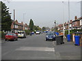
7
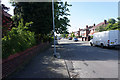
Wyverne Road
A residential road like so many others in this area.
Image: © Bill Boaden
Taken: 10 Jun 2015
0.18 miles
8
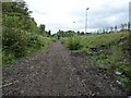
Disused railway line south east of Chorlton Junction
This was the trackbed of the former Midland Railway's Manchester South District Line from Manchester Central towards Tiviot Dale. The section from Chorlton Junction closed in the 1960s.
Since this photo was taken the section of line seen here has been re-opened as part of the Metrolink tram network. Phase 3a of the expansion plans included development of the South Manchester line as far as the new St Werburgh's Road station. The photographer's location is roughly in the vicinity of where the ramp from the island platform now stands, at the east end of the station. Tracks have been laid almost to the bridge carrying Mauldeth Road West over the line, with a head-shunt and points to allow trams to change tracks.
As part of Phase 3b, work is ongoing to extend the line towards Didsbury, with a another extension towards Manchester Airport, the junction being near Mauldeth Road West.
Image: © Phil Champion
Taken: 29 Aug 2009
0.19 miles
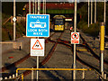
9
Tramway - Look Both Ways
Looking down the tramlines out of St Werburgh's Road tram stop.
Image: © Gerald England
Taken: 13 May 2017
0.19 miles
10
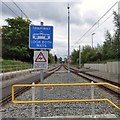
Signs at the south east end of St Werburgh's Road Metrolink station, Chorlton
Tram no. 3001 waits in the headshunt beyond St Werburgh's Road station. The South Manchester line opened in July 2011. Currently this is the end of the line, but work is underway on extensions to Manchester Airport and to East Didsbury, which diverge after St Werburgh's Road. The island platform is accessed via level crossings at both ends.
Image: © Phil Champion
Taken: 23 Jul 2011
0.19 miles