IMAGES TAKEN NEAR TO
Egerton Road North, MANCHESTER, M21 0SF
Introduction
This page details the photographs taken nearby to Egerton Road North, M21 0SF by members of the Geograph project.
The Geograph project started in 2005 with the aim of publishing, organising and preserving representative images for every square kilometre of Great Britain, Ireland and the Isle of Man.

There are currently over 7.5m images from over14,400 individuals and you can help contribute to the project by visiting https://www.geograph.org.uk
Image Map
Images are licensed for reuse under creativecommons.org/licenses/by-sa/2.0
Notes
- Clicking on the map will re-center to the selected point.
- The higher the marker number, the further away the image location is from the centre of the postcode.
Image Listing (43 Images Found)
Images are licensed for reuse under creativecommons.org/licenses/by-sa/2.0
Image
Details
Distance
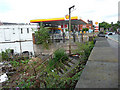
1
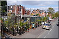
Business selling plants - Wilbraham Road, Chorlton
I'm not quite sure what you would call this place - 'garden centre' sounds rather too grand given the small scale On a small corner plot in a residential area, this place has lots of plants, as well as garden ornaments and possibly landscaping materials. I think it also extends in front of a derelict shop, just to the left. There doesn't seem to be a name for the business, and the only sign visible in this view advertises 'Land for Sale', suggesting a temporary use.
Image: © Phil Champion
Taken: 19 Apr 2014
0.07 miles
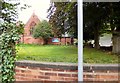
2
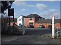
South West Manchester Cricket Club
The entrance and pavilion at South West Manchester CC. the club run three teams in the Manchester & District Cricket Association.
Image: © BatAndBall
Taken: 25 Mar 2013
0.08 miles
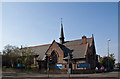
4
Wilbraham St Ninian's
St Ninian's church on Wilbraham Road.
Image: © Peter McDermott
Taken: 20 Apr 2015
0.09 miles
5
St Werburgh's churchyard
The church was founded in 1900. Prior to the Normandy invasion in 1944, St Werburgh's Church Hall was used as a base for US army legal staff billeted in nearby houses before they went over to Germany with the occupation forces to deal with war crimes.
Genuki: http://www.genuki.org.uk/big/eng/LAN/ChorltoncumHardy/StWerburgh
Image: © Gerald England
Taken: 1 Oct 2016
0.11 miles
8
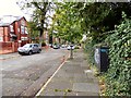
Steps to southbound platform, site of Chorlton cum Hardy station
The station at Chorlton-cum-Hardy fell to the Beeching axe and closed in 1967. The buildings and parts of the platforms were demolished shortly thereafter. The line remained open for freight only until 1988. When this photo was taken work was well under way to re-open the line, initially as far as St Werburgh's Road, as part of the expansion of the Metrolink tram network.
For many years these steps were hidden from view by vegetation. Clearance work for the Metrolink line and the new Chorlton tram stop meant they were once again visible. They have since been replaced with a new set at the same location. Behind the steps can be seen a surviving concrete lamppost.
Image: © Phil Champion
Taken: 29 Aug 2009
0.12 miles
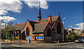
9
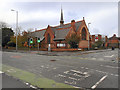
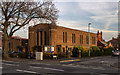
St Werburgh's Church
St Werburgh's, at the corner of St Werburgh's Road and Wilbraham Road, is an Anglican Parish Church for Chorlton and Walley Range. The church was built in 1900–02 to serve the (then new) parish of St Werburgh which had been established in 1898.
This photograph is viewing the church from across Wilbraham Road.
Image: © David Dixon
Taken: 21 Dec 2011
0.12 miles
10

Chorlton Metrolink Station
Passengers leave Metrolink tram number 3001 at Chorlton Station.
Image: © David Dixon
Taken: 25 Feb 2013
0.12 miles