Steps to southbound platform, site of Chorlton cum Hardy station
Introduction
The photograph on this page of Steps to southbound platform, site of Chorlton cum Hardy station by Phil Champion as part of the Geograph project.
The Geograph project started in 2005 with the aim of publishing, organising and preserving representative images for every square kilometre of Great Britain, Ireland and the Isle of Man.

There are currently over 7.5m images from over 14,400 individuals and you can help contribute to the project by visiting https://www.geograph.org.uk
Steps to southbound platform, site of Chorlton cum Hardy station
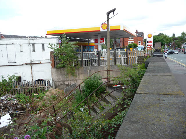
Image: © Phil Champion Taken: 29 Aug 2009
The station at Chorlton-cum-Hardy fell to the Beeching axe and closed in 1967. The buildings and parts of the platforms were demolished shortly thereafter. The line remained open for freight only until 1988. When this photo was taken work was well under way to re-open the line, initially as far as St Werburgh's Road, as part of the expansion of the Metrolink tram network. For many years these steps were hidden from view by vegetation. Clearance work for the Metrolink line and the new Chorlton tram stop meant they were once again visible. They have since been replaced with a new set at the same location. Behind the steps can be seen a surviving concrete lamppost.
Images are licensed for reuse under creativecommons.org/licenses/by-sa/2.0
Image Location
Latitude
53.442548
Longitude
-2.273055