1
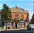
Wilmslow Road, Didsbury
Taken in 2006 to complement Peter Ward's 1955 submission (
Image). The road seems narrower - but isn't, it's just much busier. This picture was taken at about 7:15pm on a Thursday evening!
Image: © Keith Williamson
Taken: 13 Jul 2006
0.01 miles
2
Terence-Paul, Halifax and bus stop, Wilmslow Rd, Didsbury
The plaque, top, reads: 'Established 1865'.
Image: © Robin Stott
Taken: 17 Jul 2010
0.01 miles
3
Shops on Wilmslow Road, Didsbury
Image: © Eirian Evans
Taken: 10 May 2015
0.01 miles
4
A Walk in Didsbury Village (33) Halifax Building Society
On the east side of Wilmslow Road beyond the Natwest Bank (out of the picture) on the corner of Kingslynn Close is Kansas Fried Chicken which looks empty (?), Halifax building Society, Timpson and above is a hairdressing salon. The central building is quite imposing with large brick arched windows and sandstone pediments with "Established 1865" above. Doubtful that the building dates from then?
Image: © Tom Jolliffe
Taken: 20 Jul 2023
0.01 miles
5
A Walk in Didsbury Village (34) Didsbury in Bloom container
West side of Wilmslow Road. Another planted flower container with petunias. A small plane tree overhangs the pavement. Mind charity shop catches the eye on the opposite side of the road. The row of shops opposite consists of older brick built terraces. Gourmet Burger is empty, but there is no sense at all of a deserted or struggling high street. CCTV cameras are high up on a lampost.
Image: © Tom Jolliffe
Taken: 20 Jul 2023
0.01 miles
6
Dog & Partridge
On Wilmslow Road, Didsbury.
Image: © Gerald England
Taken: 1 Oct 2011
0.01 miles
7
Wilmslow Road, Didsbury
Image: © philandju
Taken: 14 Sep 2017
0.01 miles
8
A Walk in Didsbury Village (27) School Lane Junction Buildings
The old fading sign on the side of the tall building shows an old telephone number, the name of the establishment, Spanns, and vestiges of other words which have been either removed or worn away by changes, such as "LEUM" and "BEDDING". I suspect the former was linoleum (an early type of floor covering). The word "HOUSE" seems to be part of a larger word. Housewares? Warehouse? Perhaps an old photograph would answer the question. Lower down, there is a direction sign for the Baptist Church. A plane tree grows outside Costa and there are stainless steel hoops for cyclists to secure their bikes. Last, there is a branch of a bank, the NatWest, a sight which is becoming increasingly more infrequent in many places as digital accounts take (us) over.
Image: © Tom Jolliffe
Taken: 20 Jul 2023
0.01 miles
9
King's Lynn Close, Didsbury
Off Wilmslow Road, south of the junction with School Lane.
Image: © Robin Stott
Taken: 17 Jul 2010
0.02 miles
10
Didsbury Post Office
On Albert Hill Street.
Image: © Gerald England
Taken: 1 Oct 2011
0.02 miles


