IMAGES TAKEN NEAR TO
School Lane, MANCHESTER, M20 6RD
Introduction
This page details the photographs taken nearby to School Lane, M20 6RD by members of the Geograph project.
The Geograph project started in 2005 with the aim of publishing, organising and preserving representative images for every square kilometre of Great Britain, Ireland and the Isle of Man.

There are currently over 7.5m images from over14,400 individuals and you can help contribute to the project by visiting https://www.geograph.org.uk
Image Map
Images are licensed for reuse under creativecommons.org/licenses/by-sa/2.0
Notes
- Clicking on the map will re-center to the selected point.
- The higher the marker number, the further away the image location is from the centre of the postcode.
Image Listing (222 Images Found)
Images are licensed for reuse under creativecommons.org/licenses/by-sa/2.0
Image
Details
Distance
1
Restaurant
This one is called 'Hipsi'.
Funny names abound in the trendy winebar trade
Image: © Bob Harvey
Taken: 25 Oct 2017
0.00 miles
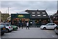
2
Barbequeue Restaurant
One of the posh restaurants in Didsbury, called 'Solita'
Image: © Bob Harvey
Taken: 25 Oct 2017
0.01 miles
3
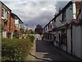
Warburton Street, Didsbury
Off Wilmslow Road by the Dog and Partridge.
Image: © Robin Stott
Taken: 17 Jul 2010
0.01 miles
4
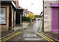
A Walk in Didsbury Village (31) School Lane
The Wishing Well down School Lane was formerly a Wetherspoons establishment which did not thrive in Didsbury. A Dental Centre is nearby.
Image: © Tom Jolliffe
Taken: 20 Jul 2023
0.02 miles
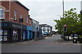
5
Warburton Road
Off Wilmslow Road by the side of the Dog & Partridge.
Image: © Gerald England
Taken: 20 May 2017
0.02 miles
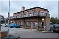
6
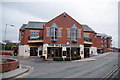
The Milson Rhodes, Didsbury
Wetherspoon's pub. Wetherspoon's usually try to name their pubs with a local connection, and this is named after a local doctor in the Victorian era who devoted himself to social reform. The rise to the right crosses a former railway which is being resurrected as a Metrolink line.
Image: © Bill Boaden
Taken: 13 Apr 2012
0.02 miles
7
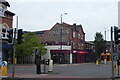
Corner of Wilmslow Road and School Lane, Didsbury
Image: © Robin Stott
Taken: 17 Jul 2010
0.02 miles
8
Insolvency accountant
Fortis offer an insolvency consultancy business
Image: © Bob Harvey
Taken: 25 Oct 2017
0.02 miles
9
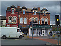
A Walk in Didsbury Village (27) School Lane Junction Buildings
The old fading sign on the side of the tall building shows an old telephone number, the name of the establishment, Spanns, and vestiges of other words which have been either removed or worn away by changes, such as "LEUM" and "BEDDING". I suspect the former was linoleum (an early type of floor covering). The word "HOUSE" seems to be part of a larger word. Housewares? Warehouse? Perhaps an old photograph would answer the question. Lower down, there is a direction sign for the Baptist Church. A plane tree grows outside Costa and there are stainless steel hoops for cyclists to secure their bikes. Last, there is a branch of a bank, the NatWest, a sight which is becoming increasingly more infrequent in many places as digital accounts take (us) over.
Image: © Tom Jolliffe
Taken: 20 Jul 2023
0.03 miles
10
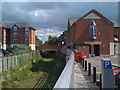
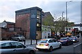
Lego comes to Didsbury
Seen from a car park off Warburton Street/Ogden Street. The bridge takes School Lane over a dismantled railway.
Image: © Robin Stott
Taken: 17 Jul 2010
0.03 miles