IMAGES TAKEN NEAR TO
Craigmore Avenue, MANCHESTER, M20 2ZL
Introduction
This page details the photographs taken nearby to Craigmore Avenue, M20 2ZL by members of the Geograph project.
The Geograph project started in 2005 with the aim of publishing, organising and preserving representative images for every square kilometre of Great Britain, Ireland and the Isle of Man.

There are currently over 7.5m images from over14,400 individuals and you can help contribute to the project by visiting https://www.geograph.org.uk
Image Map
Images are licensed for reuse under creativecommons.org/licenses/by-sa/2.0
Notes
- Clicking on the map will re-center to the selected point.
- The higher the marker number, the further away the image location is from the centre of the postcode.
Image Listing (83 Images Found)
Images are licensed for reuse under creativecommons.org/licenses/by-sa/2.0
Image
Details
Distance
1
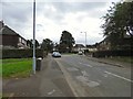
Mersey Crescent
Leading to Craigmore Avenue.
Image: © Gerald England
Taken: 9 Sep 2016
0.06 miles
2
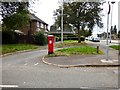
GR Postbox (M20 682D)
On the corner of Mersey Crescent and Princess Road Image
Image: © Gerald England
Taken: 9 Sep 2016
0.08 miles
3
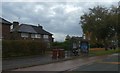
Bus shelter, Princess Road (A5103), Barlow Moor
Image: © David Smith
Taken: 24 Oct 2019
0.08 miles
4
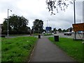
Princess Road
The A5103 approaching junction 5 of the M60. A sign on the right warns of delays on the motorway. On the left is a GR postbox Image
Image: © Gerald England
Taken: 9 Sep 2016
0.08 miles
5
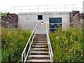
Darley Avenue Wastewater Pumping Station
By the River Mersey.
Image: © Gerald England
Taken: 21 Jul 2012
0.10 miles
6
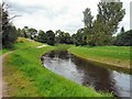
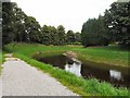
The meandering Mersey
After making a wide meander northwards towards West Didsbury the River Mersey is here turning SE. The Trans Pennine Trail follows the northern bank (though at this point it is actually SW). A cycletrack follows the southern bank (here on the NE side). On the left are the Darley Avenue wastewater pumping stations.
Image: © Gerald England
Taken: 21 Jul 2012
0.10 miles
7
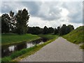
River Mersey
After making a wide meander northwards towards West Didsbury the River Mersey is here flowing SW. The Trans Pennine Trail follows the northern bank. A cycletrack follows the southern bank.
Image: © Gerald England
Taken: 21 Jul 2012
0.10 miles
8
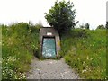
Darley Avenue Wastewater Pumping Station
By the River Mersey.
Image: © Gerald England
Taken: 21 Jul 2012
0.10 miles
9
River Mersey
After making a wide meander northwards towards West Didsbury the River Mersey is here flowing SW. The view here is upstream. The Trans Pennine Trail follows the Northern bank. A cycletrack follows the southern bank.
Image: © Gerald England
Taken: 21 Jul 2012
0.11 miles
10
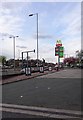
A view up Princess Road
A view up Princess Road in the Barlow Moor area of Manchester. Complete with signage for Texaco petrol and McDonald's.
Image: © Steven Haslington
Taken: 18 Apr 2017
0.13 miles