IMAGES TAKEN NEAR TO
Lapwing Lane, MANCHESTER, M20 2WR
Introduction
This page details the photographs taken nearby to Lapwing Lane, M20 2WR by members of the Geograph project.
The Geograph project started in 2005 with the aim of publishing, organising and preserving representative images for every square kilometre of Great Britain, Ireland and the Isle of Man.

There are currently over 7.5m images from over14,400 individuals and you can help contribute to the project by visiting https://www.geograph.org.uk
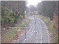
Image Map
Images are licensed for reuse under creativecommons.org/licenses/by-sa/2.0
Notes
- Clicking on the map will re-center to the selected point.
- The higher the marker number, the further away the image location is from the centre of the postcode.
Image Listing (96 Images Found)
Images are licensed for reuse under creativecommons.org/licenses/by-sa/2.0
Image
Details
Distance
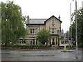
1
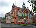
Former town hall, Lapwing Lane, Manchester
Withington's old town hall is a lively job in brick and terracotta. It was built in 1881, probably to the designs of J. Swarbrick. Grade II listed.
Now offices of solicitors, Pabla and Pabla.
Image: © Stephen Richards
Taken: 26 May 2016
0.01 miles
2
The Old Town Hall, Lapwing Lane
The former Withington Town Hall. All the other views are from Lapwing Lane, this is from Raleigh Close.
Image: © Stephen Armstrong
Taken: 18 Jul 2011
0.02 miles
3
Optician, Didsbury
This shop is on Palatine Road by Lapwing Lane. Photo taken on Boxing day when it was closed.
Image: © David Hawgood
Taken: 26 Dec 2006
0.04 miles
4
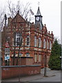
Former Withington Town Hall
This Grade II listed building is now used as commercial offices. It is in the Albert Park conservation area. Manchester City Council's description of the conservation area http://www.manchester.gov.uk/site/scripts/documents_info.php?categoryID=511&documentID=1210&pageNumber=3 tells us: "Withington Town Hall, originally the local Board of Health offices, was built in buff brick with richly decorated dressings of red brick and terracotta. These form elliptical arches over the first floor windows. The parapet is decorated with finials and has a central gable, behind which is a clock turret surmounted by a weathervane."
Image: © David Hawgood
Taken: 26 Dec 2006
0.04 miles
5
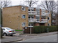
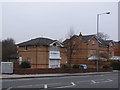
Modern flats in Withington
These flats are in Lapwing Lane, within the Albert Park conservation area - see http://www.manchester.gov.uk/site/scripts/documents_info.php?categoryID=511&documentID=1210&pageNumber=3 from Manchester council for description of the area.
Image: © David Hawgood
Taken: 26 Dec 2006
0.04 miles
6
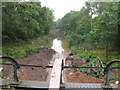
Construction of The Metrolink at West Didsbury
Taken in July 2011 from the bridge at Palatine Road / Lapwing Lane. Drainage seemed to be a problem at that time!
Image: © Stephen Armstrong
Taken: 18 Jul 2011
0.04 miles
7
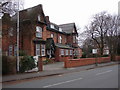
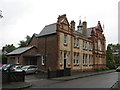
Nursing and Residential Care Home, Withington
This is Clyde Court, on Lapwing Lane.
Image: © David Hawgood
Taken: 26 Dec 2006
0.05 miles
8
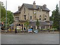
The Greenfinch, West Didsbury
Pub/restaurant at the corner of Palatine Road/Lapwing Lane.
Image: © David Dixon
Taken: 23 May 2013
0.06 miles
9
Withington & West Didsbury railway station (site), Greater Manchester
Opened in 1880 as "Withington" by the Midland Railway on the line from Chinley to Manchester Central, this station became "Withington & Albert Park" in 1884 and finally "Withington & West Didsbury" in 1914. It closed to passengers in 1961.
View north west towards Chorlton-cum-Hardy and Manchester. The only remnant appears to be the cobbled former forecourt off Lapwing Lane. The site lies about halfway between the tram stops at Burton Road and West Didsbury on Manchester Metrolink, which was built on the course of the original railway line.
Image: © Nigel Thompson
Taken: 30 Dec 2013
0.06 miles
10
the four in hand
As it was called in 2011. Now called The Greenfinch. At the corner of Palatine Road & Lapwing Lane, West Didsbury.
Image: © Stephen Armstrong
Taken: 18 Jul 2011
0.07 miles