IMAGES TAKEN NEAR TO
M19 2XR
Introduction
This page details the photographs taken nearby to M19 2XR by members of the Geograph project.
The Geograph project started in 2005 with the aim of publishing, organising and preserving representative images for every square kilometre of Great Britain, Ireland and the Isle of Man.

There are currently over 7.5m images from over14,400 individuals and you can help contribute to the project by visiting https://www.geograph.org.uk
Image Map
Images are licensed for reuse under creativecommons.org/licenses/by-sa/2.0
Notes
- Clicking on the map will re-center to the selected point.
- The higher the marker number, the further away the image location is from the centre of the postcode.
Image Listing (40 Images Found)
Images are licensed for reuse under creativecommons.org/licenses/by-sa/2.0
Image
Details
Distance
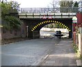
1
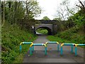
Errwood Road Bridge
A road bridge over the "Fallowfield Loop", an off-road cycleway and footpath in Manchester. The Loop is part of National Route 6 of the National Cycle Network and was previously part of the old ‘Manchester Central Station Railway’, built in the 1890s and closed in 1988
Image: © Graham Hogg
Taken: 9 May 2012
0.04 miles
2
Fallowfield Loop
Bridge carrying Alma Road across the disused railway line, the Fallowfield Loop.
Image: © Peter McDermott
Taken: 20 Apr 2015
0.04 miles
4
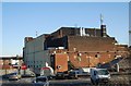
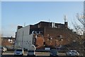
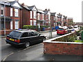
Preston Road, Levenshulme
Typical street in this somewhat down-at-heel area.
Image: © Peter Whatley
Taken: 21 Jan 2009
0.11 miles
5
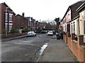
Errwood Road
From the corner of Marshall Road and Alma Road.
Image: © Gerald England
Taken: 31 Oct 2019
0.13 miles
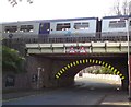
6
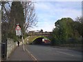
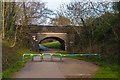
Alma Road Bridge
The bridge carries the main Manchester to Stockport railway line over Alma Road. The arch bridge has a height of 11' 3".
Image: © Gerald England
Taken: 31 Oct 2019
0.17 miles
7
Alma Road Bridge
The bridge carries the main Manchester to Stockport railway line over Alma Road. The arch bridge has a height restriction of 11' 3" (3.4m). At times of heavy rain the road underneath gets flooded.
Image: © Gerald England
Taken: 27 Oct 2019
0.18 miles
8
Alma Road Bridge
The bridge carries the main Manchester to Stockport railway line over Alma Road. The arch bridge has a height restriction of 11' 3" (3.4m).
Image: © Gerald England
Taken: 31 Oct 2019
0.18 miles