IMAGES TAKEN NEAR TO
Antrim Close, MANCHESTER, M19 1TB
Introduction
This page details the photographs taken nearby to Antrim Close, M19 1TB by members of the Geograph project.
The Geograph project started in 2005 with the aim of publishing, organising and preserving representative images for every square kilometre of Great Britain, Ireland and the Isle of Man.

There are currently over 7.5m images from over14,400 individuals and you can help contribute to the project by visiting https://www.geograph.org.uk
Image Map
Images are licensed for reuse under creativecommons.org/licenses/by-sa/2.0
Notes
- Clicking on the map will re-center to the selected point.
- The higher the marker number, the further away the image location is from the centre of the postcode.
Image Listing (99 Images Found)
Images are licensed for reuse under creativecommons.org/licenses/by-sa/2.0
Image
Details
Distance
1

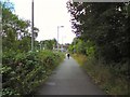
Trans Pennine Trail
The Trans Pennine Trail leading out of Green Pastures, Heaton Mersey towards a tunnel under Parrs Wood Lane Image If the Metrolink extension from East Didsbury to Stockport goes ahead then this route will be lost.
Image: © Gerald England
Taken: 30 May 2012
0.04 miles
2
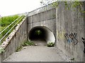
Tunnel Under Parrs Wood Road
The tunnel takes the Trans Pennine Trail from East Didsbury under Parrs Wood Lane towards Green Pastures, Heaton Mersey.
Image: © Gerald England
Taken: 30 May 2012
0.04 miles
3
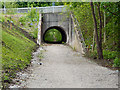
Trans Pennine Trail, Tunnel Under Parrs Wood Lane
Image: © David Dixon
Taken: 23 May 2013
0.04 miles
4
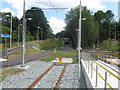
End of the line
The last few metres of Metrolink's East Didsbury route, looking toward Parrs Wood Lane/ Didsbury Road.
Image: © Peter Whatley
Taken: 24 Jul 2013
0.04 miles
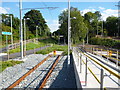
5
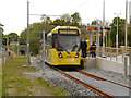
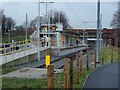
East Didsbury Metrolink Stop
Metrolink Bombardier M5000 number 3055 has just arrived at the new East Didsbury terminus of the South Manchester line, on the extension's first day of operation.
The new Metrolink line to East Didsbury, which runs along a disused railway track, opened to passenger service on Thursday 23 May, several months ahead of schedule. The 4.4km (2.7 miles) extension to the existing South Manchester line has five new stops, with services calling at Withington, Burton Road, West Didsbury, Didsbury Village and East Didsbury.
Image: © David Dixon
Taken: 23 May 2013
0.05 miles
6
Footpath to East Didsbury tram terminus
The footpath leads from Parrs Wood Lane to the tram terminus. It is also part of the Trans Pennine Trail and National Cycle Route #62. The routes were diverted when the Metrolink line was under construction in 2011/12 Image
Image: © Gerald England
Taken: 30 Jul 2018
0.05 miles
7
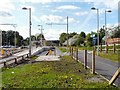
Tram terminus, East Didsbury
The start of the tracks and the station at the terminus of the tram line from the centre of Manchester. The route runs through to Oldham and Rochdale, but the line was closed for work beyond the city centre for a week in January 2014, hence the destination of Central Park being displayed.
Image: © Andrew Hill
Taken: 22 Jan 2014
0.05 miles
8
East Didsbury Tram Terminus
The terminus of the Metrolink tram line at East Didsbury opened in May 2013 three months ahead of schedule. Trams run via Trafford Bar, St Peter's Square, Victoria, Oldham to Rochdale. Alongside the line is the Trans Pennine Trail and National Cycle Network Route #62.
Image: © Gerald England
Taken: 1 Jun 2013
0.05 miles
9
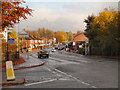
A5145 (Parrs Wood Lane/Didsbury)
Entering Stockport from East Didsbury, the A5145 changes name from Parrs Wood Lane to Didsbury Road.
Image: © David Dixon
Taken: 29 Oct 2012
0.05 miles
10
East Didsbury: Looking eastwards to the future
Looking east from the end of the Metrolink tracks at East Didsbury, the unused tunnel shows the way to Stockport, only three miles away. It can only be a matter of time before the good citizens of Stockport are asking for the extension.
Image: © Dr Neil Clifton
Taken: 22 Sep 2013
0.06 miles