IMAGES TAKEN NEAR TO
Henley Place, MANCHESTER, M19 1QE
Introduction
This page details the photographs taken nearby to Henley Place, M19 1QE by members of the Geograph project.
The Geograph project started in 2005 with the aim of publishing, organising and preserving representative images for every square kilometre of Great Britain, Ireland and the Isle of Man.

There are currently over 7.5m images from over14,400 individuals and you can help contribute to the project by visiting https://www.geograph.org.uk
Image Map
Images are licensed for reuse under creativecommons.org/licenses/by-sa/2.0
Notes
- Clicking on the map will re-center to the selected point.
- The higher the marker number, the further away the image location is from the centre of the postcode.
Image Listing (12 Images Found)
Images are licensed for reuse under creativecommons.org/licenses/by-sa/2.0
Image
Details
Distance
1
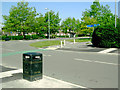
Junction of Errwood Road & Shawbrook Road, Manchester
Taken from the east side of Errwood Road, which is the slightly more distant of the two roads in the photograph.
Note that some wag has turned the blue direction signs through 90 degrees so that instead of pointing north and south along Errwood Road they now direct walkers and cyclists east and west along Shawbrook Road.
Image: © Slbs
Taken: Unknown
0.06 miles
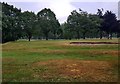
2
Heaton Moor Golf Course
A footpath crosses the golf course but there are several signs warning walkers of the potential dangers including this one: 'Beware flying golf balls. They can cause serious injury'. The course did not appear to be especially busy on this weekday just after Christmas but a group of golfers can be seen ahead.
Image: © Stephen McKay
Taken: 30 Dec 2024
0.19 miles
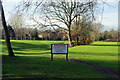
5
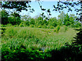
Peel Moat, Heaton Chapel
An ancient water-filled trench that provides an oasis for frogs, birds and other wildlife in the midst of Heaton Moor golf course, a more cultivated and sterile environment.
Image: © Slbs
Taken: Unknown
0.22 miles
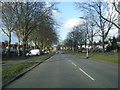
6
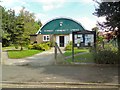
Burnage Community Centre
On Burnage Lane.
Image: © Gerald England
Taken: 24 Aug 2016
0.23 miles
7
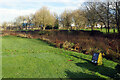
Peel Moat
Peel Moat is the site of a medieval moated house although only the overgrown and waterlogged moat itself has survived. It is now a scheduled ancient monument. The moated area is now used as part of Heaton Moor golf course for the red tee (ie women's tee) on the 15th hole.
Image: © Stephen McKay
Taken: 30 Dec 2024
0.24 miles
8
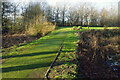
Peel Moat
Peel Moat is the site of a medieval moated house although only the overgrown and waterlogged moat itself has survived. It is now a scheduled ancient monument. A causeway allows access to the moated area and is used by golfers on Heaton Moor golf course to access one of the tees.
Image: © Stephen McKay
Taken: 30 Dec 2024
0.24 miles
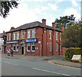
10

Sign of the Farmers Arms
Sign for the Farmers Arms Image
Image: © Gerald England
Taken: 12 Oct 2017
0.24 miles