IMAGES TAKEN NEAR TO
Burnage Lane, MANCHESTER, M19 1FE
Introduction
This page details the photographs taken nearby to Burnage Lane, M19 1FE by members of the Geograph project.
The Geograph project started in 2005 with the aim of publishing, organising and preserving representative images for every square kilometre of Great Britain, Ireland and the Isle of Man.

There are currently over 7.5m images from over14,400 individuals and you can help contribute to the project by visiting https://www.geograph.org.uk
Image Map
Images are licensed for reuse under creativecommons.org/licenses/by-sa/2.0
Notes
- Clicking on the map will re-center to the selected point.
- The higher the marker number, the further away the image location is from the centre of the postcode.
Image Listing (8 Images Found)
Images are licensed for reuse under creativecommons.org/licenses/by-sa/2.0
Image
Details
Distance
1
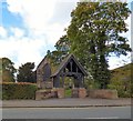
St Margaret's Church, Burnage Lane
The Grade II listed church https://historicengland.org.uk/listing/the-list/list-entry/1407271 opened in 1875. Construction took place in phases between 1874 and 1926. In 1919 a lych gate was erected as a war memorial https://www.iwm.org.uk/memorials/item/memorial/10719 to the parishioners killed during WWI, which was presented to the community by Alderman Lieut-Col T Turnbull.
Church website: http://www.stmargaretsburnage.org.uk/
Image: © Gerald England
Taken: 12 Oct 2017
0.16 miles
2
Burnage United Reformed Church
A 1990s replacement for a Victorian building (note the original gateposts).
Image: © John H Darch
Taken: 8 Sep 2010
0.18 miles
4

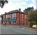
Sign of the Farmers Arms
Sign for the Farmers Arms Image
Image: © Gerald England
Taken: 12 Oct 2017
0.18 miles
5

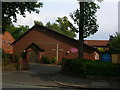
Burnage Community Centre
On Burnage Lane.
Image: © Gerald England
Taken: 24 Aug 2016
0.19 miles
6
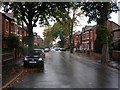
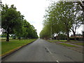
Burnage on a wet afternoon.
Looking west along Grangethorpe Drive, Burnage, Manchester Typical street for this square. SJ86749327
Image: © Keith Williamson
Taken: 12 Oct 2005
0.21 miles
8
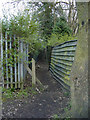
Bibby Lane, Burnage
Bibby Lane is an ancient path which once directed the public through farmland, it is now a dilapidated dark path through undergrowth linking Burnage Lane and Bournelea Avenue. Ancient cobbles are still visible at points.
Image: © Matthew Wilkinson
Taken: 13 Mar 2003
0.24 miles