IMAGES TAKEN NEAR TO
Mauldeth Road, MANCHESTER, M19 1AA
Introduction
This page details the photographs taken nearby to Mauldeth Road, M19 1AA by members of the Geograph project.
The Geograph project started in 2005 with the aim of publishing, organising and preserving representative images for every square kilometre of Great Britain, Ireland and the Isle of Man.

There are currently over 7.5m images from over14,400 individuals and you can help contribute to the project by visiting https://www.geograph.org.uk
Image Map
Images are licensed for reuse under creativecommons.org/licenses/by-sa/2.0
Notes
- Clicking on the map will re-center to the selected point.
- The higher the marker number, the further away the image location is from the centre of the postcode.
Image Listing (32 Images Found)
Images are licensed for reuse under creativecommons.org/licenses/by-sa/2.0
Image
Details
Distance
1
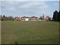
Burnage Cricket Club - Ground
Burnage CC's Mauldeth Road Ground.
Image: © BatAndBall
Taken: 25 Mar 2013
0.11 miles
2
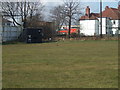
Burnage Cricket Club - Scorebox
Burnage CC play in the Manchester & District Cricket Association.
Image: © BatAndBall
Taken: 25 Mar 2013
0.15 miles
3
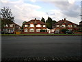
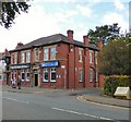
225 to 233 Kingsway, Burnage
From left to right are house numbers 225 to 233 on Kingsway, a major thoroughfare in the Burnage area of Manchester, Greater Manchester, England. Overwhelmingly, Burnage consists of this style of semi-detached suburban housing.
Image: © Steven Haslington
Taken: 3 Aug 2011
0.16 miles
4
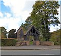
St Margaret's Church, Burnage Lane
The Grade II listed church https://historicengland.org.uk/listing/the-list/list-entry/1407271 opened in 1875. Construction took place in phases between 1874 and 1926. In 1919 a lych gate was erected as a war memorial https://www.iwm.org.uk/memorials/item/memorial/10719 to the parishioners killed during WWI, which was presented to the community by Alderman Lieut-Col T Turnbull.
Church website: http://www.stmargaretsburnage.org.uk/
Image: © Gerald England
Taken: 12 Oct 2017
0.16 miles
5
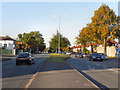
Kingsway (A34)
Looking north (towards Manchester) from the Mauldeth Road junction on Kingsway.
Image: © David Dixon
Taken: 28 Sep 2011
0.16 miles
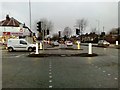
6
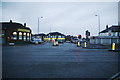
The junction of Mauldeth Road and Kingsway, Burnage
Taken in early morning light.
Image: © Bill Boaden
Taken: 27 Dec 2012
0.17 miles
8
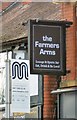
Sign of the Farmers Arms
Sign for the Farmers Arms Image
Image: © Gerald England
Taken: 12 Oct 2017
0.17 miles
9
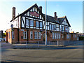
The Mauldeth
Large public house at the junction of Kingsway (A34) with Mauldeth Road
Image: © David Dixon
Taken: 28 Sep 2011
0.18 miles